|
||

|

|
|

|
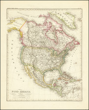
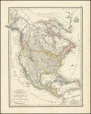
Marvelous highly detailed map of North America from Hall's New General Atlas. Includes Texas, named as a Mexican Intendency, a massive Western (Oregon) Territory w/54-40 or fight border with British America, massive Missouri Territory extending to the Rocky Mtns, Russian Territory (with northern coastline partially unknown) and many other early features. The Rio Buenaventura reaches from Monterrey on the Pacific to the mythical lake Teguayo beneath Lake Timpanagos (Salt Lake), which has its outlet in San Francisco Bay, via the Rio Sacremento. The Rio de los Martires reaches from north of San Diego Bay to Southern Utah. The Colorado River headwaters are well north of the true source. Most of the California Missions are shown. In Oregon Territory, New New Albion and New Georgia appear prominently, along with Lewis & Clark information. The area is filled with Indian Tribes, Forts and Villages. Canada and the region west of the Great Lakes provide remarkable detail of the various drainages and rivers. Mackenzie River extends from Slave Lake to the Arctic Ocean. The NW Passage is nearly charted, ending at Melville Sound and Ft. Turnagain, south of Banke's Land and Melville Island. Lewis & Clark's Stinking Water River is shown, just east of the Rocky Mtns. The 54-40 or fight border is of considerable note on an English map, given that this position was contrary to English Political Interests. One of the best large format English maps of the period. Wheat 386.
![[Pan American Menu Map] North America](https://storage.googleapis.com/raremaps/img/small/103976.jpg)