|
||

|

|
|

|
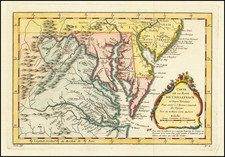
Rare first state of one of the finest and earliest Dutch charts of New Netherlands, New England and the Chesapeake Region, which first appeared in Doncker's Sea Atlas of 1660.
Doncker's sea chart of the region is preceded only by the now virtually unobtainable sea charts by Jacobsz (c.1650) and Colom (1656). Koeman writes that Doncker's charts, "were the most up to date charts published in the second half of the 17th century," and goes on to note that "more frequent than Goos, Lootsman, Van Loon, and other contemporaries, Hendrik Doncker corrected and improved his charts. He often replaced obsolete charts by new ones... This consciousness of the high demand of correctness is reflected by the development of Doncker's sea atlas" -- Koeman.
In this chart, Doncker gives an fine rendering of the coast from below the Chesapeake Bay north to just north of Cape Cod. The Hudson River is shown as far north as Albany, which is marked here as Fort Orange. In New York Harbor, Manhattans, Nieuw Amsterdam, and Staten Eylant are all named. Burden notes that, although much of the chart follows Colom, the use of Chesipioock at the northern end of the outer banks south of Cape Henry points to the De Bry/White map of 1590.
This rare first state can be identified by the printed date 1660 in the title. As with most of Doncker's charts, the copperplate was re-worked over its publication history and Burden notes two later states of c.1669 and c.1676. The chart was published in Doncker's Zee-Atlas ofte Water-Waereld. According to Koeman, "Doncker was the first cartographer to bring out a sea atlas after Arnold Colom's venture of that kind between 1654 and 1658." The Zee-Atlas first appeared in 1659, but no surviving example of the 1659 edition is known. This particular chart was not available until the 1660 edition.
Hendrik Doncker was a famous bookseller in Amsterdam, who started with the age of 22 years and ran his shop successfully for fifty years. He published his first sea atlas around 1659. Due to the fact, that Hendrik Doncker corrected and improved his charts more frequent then other well known map makers, as van Loon, Goos or Theunis, his business was quite successful and there was a high demand for his works and this reflected also the various improved and corrected editions of sea atlases he published. This map was published in a composit sea atlas by Pieter Goos, who was 'one of the best known maritime booksellers of Amsterdam' (Koeman), he published a number of different sea-atlases or pilot books, his work was very much derivative. With his 'Zee-Atlas' he relied heavily on Hendrick Doncker's 'Zee-Atlas' of 1659.
Hendrik Doncker was a prominent bookseller in Amsterdam best known for his sea charts and nautical atlases. He issued his own original charts, which he updated frequently, and also worked with colleagues like Pieter Goos, for example to produce the pilot guide, De Zeespeigel. He died in 1699, after fifty years in business. His plates then passed to Johannes van Keulen.