


|
||

|

|
|

|
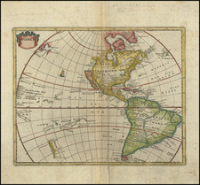
Nice example of John Senex's decorative map of America.
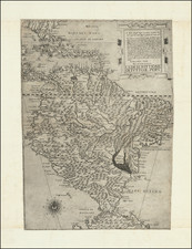
Senex's map is curious for several reasons. First, unlike most maps of the period, Senex adds a conjectural Northwest Coastline, which includes a number of islands and several lakes, including Aquinonbock, Lake of Isles, and the The Great Lake of Thoago or Thoya. On the coastline, Desolation and Zapozipin Bays appear north of 60 degrees.
Two other remarkable features in Senex's map includes the odd unnamed river with its headwaters in the Florida panhandle and the unique shape of South America. Remarkably, this is one of the few English Language maps to show California as an island, appearing after Kino's location of the headwaters of the Colorado debunked the insular myth. It is indeed curious that despite noting the islands and other features along the Northwest coast, Wagner gives no real explanation of the source of the information, which certainly predates the Russian discoveries and information furnished by Joseph De L'Isle and Philippe Buache.
The only other appearance of this odd coastline would appear to be in the 1703 edition of Peter Heylyn's Cosmography. Mead Cain wrote in TMC 57 that the source of the map was Robert Morden. Both maps include the odd coastline and apophrycal river rising from the Florida Panhandle. The river rising from the Florida Panhandle is oddly lacking on Senex's edition of the Browne map.
John Senex (1678-1740) was one of the foremost mapmakers in England in the early eighteenth century. He was also a surveyor, globemaker, and geographer. As a young man, he was apprenticed to Robert Clavell, a bookseller. He worked with several mapmakers over the course of his career, including Jeremiah Seller and Charles Price. In 1728, Senex was elected as a Fellow of the Royal Society, a rarity for mapmakers. The Fellowship reflects his career-long association as engraver to the Society and publisher of maps by Edmund Halley, among other luminaries. He is best known for his English Atlas (1714), which remained in print until the 1760s. After his death in 1740 his widow, Mary, carried on the business until 1755. Thereafter, his stock was acquired by William Herbert and Robert Sayer (maps) and James Ferguson (globes).