


|
||

|

|
|

|
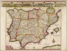
Full original color example of J.B. Homann's map of the Iberian Peninsula, with an extraordinary full original color cartouche.
Johann Baptiste Homann, patriarch of this important 18th Century family of map makers whose work dominated German cartographic publishing for over 100 years, produced at least 3 different maps of Iberia which bear his name. The present example may be distinguished by the presence of a second title (
El Reyno De Espanna divido en dos grandes Estados De Aragon Y Castilla, sudividido en mucas Provincias, donde se halla tambien El Reyno de Portugal) and the scale of miles in the lower left corner. Other editions of the map include an edition with the same title cartouche and decorative embellishments in the upper right corner, but with a different scale in the lower left and an edition with a cartouche in the lower right corner and an elaborate military battle between the cartouche and the Mediterranean coastline of Spain and a slightly different title.
The map provides a detailed coverage of the geographical and topographical features of Spain & Portugal, including cities, towns, castles, mountains, rivers and most notably, a number of early roads. The present example of the map is also extraordinary for its inclusion of an original color cartouche. While we have seen many examples of this and other Homann maps, this is the first time that we have seen the map with a full color cartouche which was colored at the same time as the rest of the map.
Johann Baptist Homann (1663-1724) was a mapmaker who founded the famous Homann Heirs publishing company. He lived his entire life in Bavaria, particularly in Nuremberg. Initially, Johann trained to become a priest before converting to Protestantism and working as a notary.
In 1702, Johann founded a publishing house that specialized in engravings. The firm flourished, becoming the leading map publisher in Germany and an important entity in the European map market. In 1715, Johann was named Imperial Geographer to the Holy Roman Empire by Charles VI and made a member of the Prussian Academy of Sciences. Most importantly for his business, his reputation and contacts gained him imperial printing privileges which protected his publications and recommended him to customers. Johann is best known for this Grosser Atlas ueber die ganze Welt, or the Grand Atlas of the World, published in 1716.
After Johann died in 1724, the business passed to his son, Christoph (1703-1730). Upon Christoph’s early death, the company passed to subsequent heirs, with the name of the company changing to Homann Erben, or Homann Heirs. The firm continued in business until 1848.
![Regnorum Hispaniae et Portugalliae Tabula Generalis jam nuper edita . . . [includes Balearic Islands]](https://storage.googleapis.com/raremaps/img/small/79438.jpg)
![[Bay of Biscay] Paskaerte Vande Bocht van Vranckrijck Biscajen en Galissen tuscchen Heylant en C. de Finisterre](https://storage.googleapis.com/raremaps/img/small/83967.jpg)