This item has been sold, but you can enter your email address to be notified if another example becomes available.


|
||

|

|
|

|
Stock# 18528
Description
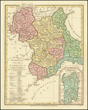
Detailed map of Sardinia and Corsica, showing the various towns, mountains, rivers, provinces, bays, and smaller islands.
The present example includes the revised decorative roccoco borders, which include a more refined engraving style and reduced size for the text panels. Decorative cartouche and ornate architectural style border, with embellishments throughout.
![[ Confederate States of America Naval Flag! ] Pavillons des Principales Puissances](https://storage.googleapis.com/raremaps/img/small/88973.jpg)