|
||

|

|
|

|
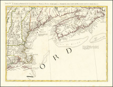
Scarce map of region from Cape Cod to the Chesapeake and Cape Hatteras, engraved by James Turner of Boston and published and sold by Ben Franklin. One of only a few maps of America published before 1750 which is obtainable by a collector and the earliest obtainable map to provide meaningful detail in the Chesapeake, preceded only by Benjamin Franklin's rare re-printing of the Senex edition of the Penn-Lord Baltimore Treaty Map.
The map is one of three published to accompany A Bill in the Chancery of New-Jersey, published by James Alexander in 1747. The Bill in the Chancery . . . represents the legal argument of the Proprietors of East New Jersey to represent their point of view in a land dispute with settlers around Elizabeth, which was filed in 1745. The controversy began in March 1664 when Charles II conveyed all of the land between the Connecticut colony and the Delaware River to the Duke of York. The Duke of York sent Colonel Richard Nicolls to capture the Middle Atlantic colonies. By May, the region was under English rule and Nicolls was appointed governor. The Duke of York subsequently granted the New Jersey proprietary to Lord Berkeley, and Sir George Carteret. Before Nicolls learned of the grant, he gave the settlers living in the area of Elizabethtown permission of purchase titles to their lands from the Delaware Indians. Nicolls's actions led to years of litigation over who actually held title because the settlers claimed possession based on their Indian deeds and the Proprietors maintained that the lands belong to the proprietorship.
The maps were drafted by Alexander. Lewis Evans originally received a commission to produce 40 manuscript copies of each map. However, when the print run of the Bill in the Chancery increased to 250, at Benjamin Franklin's advice, Alexander elected to have James Turner of Boston engrave the maps. Map No. I depicts the American colonies from Boston to Cape Hatteras and provides broad geographic context. The text of the Bill in the Chancery states that Map No. I was "copied from part of Popple's large Map of the English Colonies in America . . ." The elaborate cartouche includes a table showing differences between Dutch and British toponymy and a key to color coding the aforementioned boundary lines (This example of the map is uncolored, as are all copies we have seen.)
James Turner was a most important silversmith and engraver active in Boston and then Philadelphia, where he died in 1759. In addition to the maps for the Bill in Chancery, he engraved the plates for Lewis Evans' General Map of the Middle Colonies in America (1755) and Nicholas Scull's maps of Pennsylvania (1759) and Philadelphia (1762).