|
||

|

|
|

|
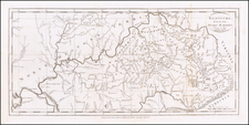
Extraoridinarily detailed Revolutionary War ear map of the Gulf Coast from the Appalachia River in Florida to the Red River in Louisiana, centered on the course of the lower Mississippi, Mobile Bay and Pensacola Bay.
The map extends inland along the Mississippi to approximately the Mississippi-Louisiana border. The map includes rhumb lines, hundreds of soundings, anchorages, and notes of early settlements. There are also nots concerning Crevecoeur and a Spanish landing in 1718 and 1719. The map first appeared in 1778, for the Depot General de la Marine under the direction of M. de Sartine. This well engraved and highly detailed chart was issued in Neptune americo-septentrionale and was intended for use by the French Navy during the Revolutionary War.


![[Jefferson's Notes on the State of Virginia] Observations sur la Virginie [with the map:] A Map of the country between Albemarle Sound, and Lake Erie, comprehending the whole of Virginia, Maryland, Delaware, and Pensylvania, with parts of several other of the United States of America. Engraved for the Notes on Virginia.](https://storage.googleapis.com/raremaps/img/small/51828.jpg)