This item has been sold, but you can enter your email address to be notified if another example becomes available.


|
||

|

|
|

|
Stock# 17401
Description
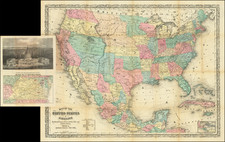
Interesting and detailed map of the US and Canada, extending nearly to the Rocky Mountains. Texas is named, but not yet shown as a republic, although the map includes at least a dozen place names and shows the road from Natchtoches to the Presidio de Rio Grande. The west and old Northwest are dominated by the Huron, Sioux, Mandan, Osage and Ozark Districts, with many Indian Tribes located therein. Arkansas is shown as a territory Michigan is still a Territory. There are a number of early roads and forts located throughout the map. An excellent early map. edition of the map, following the first edition of 1837. This is the first edition to show Texas as a Republic. One of the earliest maps published by Andriveau-Goujon.
![Partie du Cours du Fleuve de Saint Laurent depuis Quebec jusqu'au Cap aux Oyes [on sheet with] Carte du Cours du Fleuve Saint Laurent depuis Quebec jusqu'a la Mer en Deux Feuilles ... 1761](https://storage.googleapis.com/raremaps/img/small/55185.jpg)
![For Governor, Maj. Gen. John W. Geary [Former Mayor of San Francisco / Governor of Kansas Territory and Governor of Pennsylvania]](https://storage.googleapis.com/raremaps/img/small/93592.jpg)