


|
||

|

|
|

|
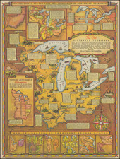
Important separately issued map of the old Northwest Territory, published shortly after the Treaty of Greenville, illustrating the region which would become the Old Northwest Territory and Ohio.
The Treaty of Greenville was signed at Fort Greenville (Greenville, Ohio), on August 2, 1795, between a coalition of Native Americans known as the Western Confederacy and the United States following the Native American loss at the Battle of Fallen Timber. This ended the so-called Northwest Indian War. The United States delegation was represented by General "Mad Anthony" Wayne, who led the victory at Fallen Timbers. In exchange for goods to the value of $20,000 (such as blankets, utensils, and domestic animals), the Native Americans turned over to the United States significant lands in the midwest, including large parts of modern-day Ohio, the future site of downtown Chicago, the Fort Detroit area, Maumee Ohio Area, and the Lower Sandusky Ohio Area.
The treaty established what became known as the "Greenville Treaty Line," which was for several years a boundary between Native American territory and lands open to white settlers. In reality, the treaty line was frequently disregarded by settlers as they continued to encroach on native lands guaranteed by the treaty. The treaty line began at the mouth of the Cuyahoga River in present-day Cleveland. It ran south along the river to the portage between the Cuyahoga and Tuscarawas River in what is now known as the Portage Lakes area, between Akron and Canton. The line continued down the Tuscarawas to Fort Laurens near present-day Bolivar. From there, the line ran west-southwest to near present-day Fort Loramie on a branch of the Great Miami River. From there, the line ran west-northwest to Fort Recovery, on the Wabash River near the present-day boundary between Ohio and Indiana. From Fort Recovery, the line ran south-southwest to the Ohio River at a point opposite the mouth of the Kentucky River, in present-day Carrollton, Kentucky.
William Clark of the Lewis and Clark Expedition was present at Greenville. Years later he met again one of the Delaware chiefs he had met at the conference, noting in his journal for December 23, 1803: "a rainey day… several Deleaway pass, a chief whome I saw at Greenville Treaty, I gave him a bottle of whiskey."
This treaty is notable for ceding 16 plots of land to the United States, which were to become Chicago, Fort Defiance, Fort Wayne, and other prominent cities and towns. Other notable features on his map are the Connecticut Lands [an area in northeast Ohio that the State of Connecticut had reserved for its citizens in 1786], the Army Lands, the Seven Ranges, Siota Grant, and Ohio Company lands. This map occasionally appears in composite copies of Mathew Carey's atlases of 1796, 1802, 1809, and 1812.

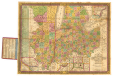

![[Eastern Sheet -- Ohio] Post Road Map of the States of Ohio and Indiana with Adjacent Parts of Pennsylvania Michigan Illinois Kentucky and West Virginia Showing Post Offices With The Intermediate Distances and Mail Routes In Operation On the !st of February 1885 . . .](https://storage.googleapis.com/raremaps/img/small/44153.jpg)
