|
||

|

|
|

|
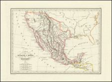
Pedro Garcia Conde's map of Mexico is the sole surviving cartographic record of Mexico's first indigenous survey, and the only large format printed map produced from indigenous Mexican sources to include Texas & Upper California as part of Mexico. The map is based upon a larger manuscript map of Mexico compiled by Garcia Conde at the request of the Mexican Government (now lost), making this map the only surviving record of Garcia Conde's original work. Perhaps even more remarkable, Garcia Conde, who was the chief Boundary Commssioner for Mexico, in effecuating the Treaty of Guadalupe-Hidalgo, managed to completely conceal from the Mexican Government (and as a result Mexico's earliest map makers and historians), the existence of the printed map which he had surreptiously caused to be produced on his visit to London in 1845.
Despite the iconic status of the second edition of the manuscript survey map (which is widely regarded as one of Mexico's national treasures and displayed prominently in the archives of the SMGE in Mexico City), the very existence of this earlier printed edition of the first edition of the map, was unknown to Mexican scholars until January 2007. A copy of the map was shown to UNAM professor Hector Mendoza Vargas, Mexico's leading cartographic scholar and author of the most authoritative work on the indigenous mapping of Mexico, during the early history of the Republic.
Latin America's first geographic society, the Instituto Mexicana de Geografia y Estadistica (later Sociedad Mexicana Geografia y Estadistico or SMGE), was created in 1833 by President Valentin Gomez Farias, in order to accumulate and produce geographical and statistical knowledge of the vast Mexican Republic, and provide legitimacy to its status as an independent nation. Despite Mexico's turbulent political history, the SMGE was embraced and consistently funded by the federal government. Shortly after Mexican Independence, SMGE became the primary repository and catalyst for the indigenous surveying and mapping of Mexico.
One of SMGE's first major projects was to create a Carta General of the newly created Republic. For this purpose, SMGE commissioned Pedro Garcia Conde to create the first indigenous map of Mexico. Rather than gathering the information by formal survey, Garcia Conde prepared and distributed a questionaire throughout the Republic, in which he sought information on the towns, villages, mines, mountains, rivers and other cartogaphic features of the country. With the responses to his questionaire, he prepared a large scale manuscript map, with the intention of producing the first printed map of the Republic. Unfortunately, fate and the underfunded status of the Mexican Government intervened. Garcia Conde travelled to America, Paris and London, in an effort to find a pubisher for the map, only to meet with disappointment.
Finally, in apparent frustration, Garcia Conde collaborated with Benjamin Rees Davies, then one of London's leading independent map engravers, to make a reduced version of the map. The work was apparently undertaken in secret and without the knowledge of the Mexican Government. According to UNAM Professor Hector Mendoza Vargas, when word got back to Mexico City that Garcia Conde was attempting to have a copy of the map engraved privately, he received a stern written centure from SMGE. However, it is now clear that Garcia Conde concealed both the completion and existence of his printed version of the Carta General from SMGE and the Mexican Government, as no copy of the map is known in Mexico and none of the contemporary or modern scholars on the history of the mapping of Mexico mention the map. Professor Vargas (in a meeting in January 2007, in Mexico City) acknowledged that he was not aware of the map's existence, a fact confirmed the following day in a meeting at the National Archives with the chief archivist, Carlos Vidali Rebolledo.
The map apparently reflects the progress of Garcia Conde's manuscript map through 1845, shortly before the start of the Mexican-American War. At that time, Garcia Conde was called upon by President Santa Anna to return to military service. At this point, work on the manuscript Carta General was likely suspended. Later, after the end of the War, an updated manuscript of the map was created (the second state), which hangs to this day in the halls of the SMGE. It would seem however, that the original Gracia Conde Carta General on an "escala mayor" (larger scale) has been lost, leaving the Benjamin Rees Davies imprint as the only record (printed or otherwise) of its content and Garcia Conde's work.
The lack of any knowledge of the existence of Garcia Conde's map is clear in the writings of some of his contemporaries. Antonio Garcia Cubas (maker of the first official map of Mexico in 1863), states in his summation of the Armistance of 1847, "our history is written simply by saying the Mexico and the United States are neighbors. At least France and England are separated by a Channel; between our nation and our neighbor there exists no other border than a simple mathematical line . . . God help the Republic!" ( Collado, Antonio Garcia y Cubas, p.443). Similarly, the members of the Comision de Estadistica Militar in 1848 stated, "How can one expect to understand the nation's territorial extension, or consult regarding its defense, without the formation of a general map and one of each State and territory (see Mendoza Vargas, 55). Translations are from Craib, Cartographic Mexico….
In Cartographic Mexico, Craib notes:
Under these less than auspicious circumstances the SMGE's new national map, hastily finished in the aftermath of the War and during the initial phases of the boundary demarcation, appeared in 1850. . . . It included a visual elaboration of the territory lost in the Treaty of Guadalupe-Hidalgo, as well as a demarcation of the new international limits between Mexico and the United States. . . .[According to Garcia Cubas in his El Libro de mis recuerdos (p.452)], the image brought an expression of bitterness from General Santa Anna, who for the first time could actually envision the magnitude of the territory Mexico had lost. The map never saw publication because of the government's precarious financial condition after the war. Members of the Comision and [SMGE] sought publishers in the United States and England, but found the prices for publication no more accomodating than Mexico. . . .
The need for a published and circulated Mexican-produced national map became even more pronounced when in 1854, Mexico lost another portion of its territorial claim as a result of [the Disturnell] map. . . . Regardless of the role General Antonio Lopez de Santa Anna and others played in the politics of the [Gadsden] Purchase, Mexican officials and intellectuals were convinced: Mexico needed an accurate and internationally accepted map of its own, published and circulated.
After the war, a new Carta General, constructed by Garcia Cubas, would proffer an iconographic image of the state's new parameters and fill that territory with the ghosts of the past, in the process creating an image of a single national spirit.
Craib (p. 25-27). (For further reading, see Mendoza Vargas' Historia de la geografia de Mexico unpublished thesis residing in the Garcia y Cubas Library at UNAM and Manuel Orozco y Berra's Apuntes para la historia de la geografia en Mexico (1881).
Pedro Garcia Conde's map of Mexico is based upon his manuscript map of Mexico which had been prepared by 1845 and existed in manuscript form at that time. The "Nota" below the title indicates that a larger scale map was then in preparation, although there is no evidence to support the existence of anything other than the manuscript copy. The map is an amalgam of information which was compiled by SMGE under Garcia Conde's supervision. At least one commentator has identified information in Garcia Conde's map which would have derived from 18th Century Mexican archival information which does not appear on contemporary American maps.
The cartography of Upper California, especially as it relates to the regions between California and the Rocky Mountains is often very dated. The map includes the mythical river connecting San Francisoc Bay with Lake Timpanagos (Salt Lake), and the mythical second lake (Teguayo), along with many other features near the Rocky Mountains which would have been out of date by 1845. However, south of these regions, the map is remarkably accurate, perhaps more so than any American maps. For instance, El Paso, while unnamed, appears to be accurately placed (unlike Disturnell's map).
The rationale for the preparation of the map is reportedly a desire by the Mexican Government to produce a large scale, up-to-date, map of the Republic of Mexico. The Garcia Conde map in fact notes below the explanatory key that it was prepared from (at the request of?) official Mexican Government Records. Yet it is equally clear that Mexican historians and scholars were not aware of the map's existence until this example appeared in 2007.
There are two extent "states" of the map known to date. The first (1 example-British Library), is colored to reflect a pre-1846 Mexican-American Border as the Mexicans would have advocated, showing Upper California, New Mexico and Texas as part of Mexico. All other extent copies (4 or 5 known) of the map are colored to reflect the boundaries as set (more or less), by the Treaty of Guadalupe Hidalgo.
![(Mexican-Aztec Painting) [Watercolor of four Aztec deities from the Codex Telleriano Remensis and Codex Vaticanus]](https://storage.googleapis.com/raremaps/img/small/103011.jpg)
![[ Chinese Voyages To America, etc. ] Memoires De Litterature, Tires Des Registres De L'Academie Royale Des Inscriptions et Belles-Lettres Depuis l' annee M. DCC. XVIII. julques & compris l'annee M. DCC. XXV Tome Quarante-Neuvieme](https://storage.googleapis.com/raremaps/img/small/101296.jpg)
![[ San Francisco and California Coast to Central Baja ] Cote Nord-Ouest De L'Amerique Reconnue par le Cape. Vancouver Ie. Partie . . .](https://storage.googleapis.com/raremaps/img/small/82224.jpg)