|
||

|

|
|

|
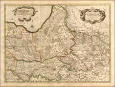
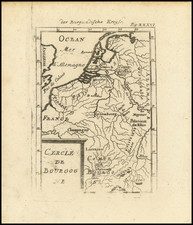
Early state of Blaeu's map of the Fossa Eugeniana, an early canal which was intended to connect the Maas River (at Venlo) with the Rhine at Rhynberk.
The map first appeared in Blaeu's Appendix in 1630, but the present example is a revised state, per Keuning (Imago Mundi XIV, pp 74-89). Striking early impression, in full color. A highly detailed map of the rgion, extending south to Kempen and north to Santen. From the 1634 edition of Blaeu's Atlas Novus, the first edition of this work.
Willem Janszoon Blaeu (1571-1638) was a prominent Dutch geographer and publisher. Born the son of a herring merchant, Blaeu chose not fish but mathematics and astronomy for his focus. He studied with the famous Danish astronomer Tycho Brahe, with whom he honed his instrument and globe making skills. Blaeu set up shop in Amsterdam, where he sold instruments and globes, published maps, and edited the works of intellectuals like Descartes and Hugo Grotius. In 1635, he released his atlas, Theatrum Orbis Terrarum, sive, Atlas novus.
Willem died in 1638. He had two sons, Cornelis (1610-1648) and Joan (1596-1673). Joan trained as a lawyer, but joined his father’s business rather than practice. After his father’s death, the brothers took over their father’s shop and Joan took on his work as hydrographer to the Dutch East India Company. Later in life, Joan would modify and greatly expand his father’s Atlas novus, eventually releasing his masterpiece, the Atlas maior, between 1662 and 1672.