This item has been sold, but you can enter your email address to be notified if another example becomes available.


|
||

|

|
|

|
Stock# 1473
Description
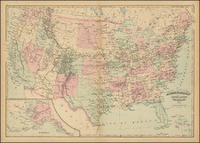
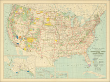
Terrific map of the US, extending well west of the Rocky Mountains, intended to illustrate the Free, Slave and Border States during the Civil War. An excellent Transmississippi West map, showing a massive Dakota, no Idaho, newly formed Colorado and all of Utah (with Arizona still below according to the Baylor Line) and Washington extending to the Rocky Mountains, wrapping around Oregon (not shown). Terrific topographical detail throughout, with roads, rivers, lakes, mountains, forts, Indian info, etc. An excellent map of the period.
![(Puzzle Map) Mapa de America Del Norte y Central Razas y Fauna Del Continente [Map of North and Central America Races and Animals of the Continent]](https://storage.googleapis.com/raremaps/img/small/91115.jpg)