|
||

|

|
|

|
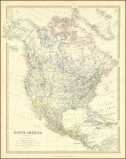
Striking example of Jaillot's map of North America, based upon the earlier maps of Nicholas Sanson.
California is shown as an island. The Great Lakes are shown with open ends in the West. Excellent detail in California and the Southwest, including the 7 cities of Cibola. A continuous land mass west of California is labeled Iesso. Excellent detail throughout the Eastern US, where the Sanson cartography remains in evidence, especially along the Gulf Coast.
This example was issued by Ottens, using the original Jaillot plate and includes attractive old color. There exists are rare 4th State, where California is no longer shown as an island: /gallery/detail/003ms
The Ottens brothers, Reiner and Joshua, operated a successful printing partnership in the mid-eighteenth century (fl. 1726-1765). They began the venture in 1726, publishing maps and other prints as “R & I Ottens.” They specialized in the reprinting of others’ work, especially Guillaume De L’Isle. In 1750, Reiner died; his soon, also Reiner, took his place, but the firm began listing their works as “Joshua & Reiner Ottens.” The firm lasted until Joshua’s death in 1765. Joshua’s widow, Johanna de Lindt, sold their remaining stock of plates in 1784.
Alexis-Hubert Jaillot (ca. 1632-1712) was one of the most important French cartographers of the seventeenth century. Jaillot traveled to Paris with his brother, Simon, in 1657, hoping to take advantage of Louis XIV's call to the artists and scientists of France to settle and work in Paris. Originally a sculptor, he married the daughter of Nicholas Berey, Jeanne Berey, in 1664, and went into partnership with Nicholas Sanson's sons. Beginning in 1669, he re-engraved and often enlarged many of Sanson's maps, filling in the gap left by the destruction of the Blaeu's printing establishment in 1672.