


|
||

|

|
|

|
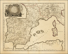
Gorgeous full color example of Luggert van Anse's 4 sheet map of Spain, Portugal and the Balaeric Islands, joined flawlessly and presented here as a wall map.
Includes a large cartouche with explanations of the political divisions of Spain and Portugal in French and Dutch, headed by coat of arms and 6 compass roses. An uncommon wall map of Spain and Portugal. Luggert van Anse was engraver for Allard, Visscher and van Keulen. This edition was published by Ottens, with additions and corrections. A spectacular example.
The Ottens brothers, Reiner and Joshua, operated a successful printing partnership in the mid-eighteenth century (fl. 1726-1765). They began the venture in 1726, publishing maps and other prints as “R & I Ottens.” They specialized in the reprinting of others’ work, especially Guillaume De L’Isle. In 1750, Reiner died; his soon, also Reiner, took his place, but the firm began listing their works as “Joshua & Reiner Ottens.” The firm lasted until Joshua’s death in 1765. Joshua’s widow, Johanna de Lindt, sold their remaining stock of plates in 1784.
![[Portugal / Morocco / Azores & Canary Islands] Pascaarte Van Barbarische cust mitsgaders van de Canarische en Vlaemsche Eijlanden](https://storage.googleapis.com/raremaps/img/small/75279.jpg)
![[Portugal] Pascaarte vande Zeecusten van Portugal tusschen de Barlenges en de C. de S. Vincente geleghen, vertoonende nae't leven de ware geleghentheijt vande vermaerde Riviere van Lisbona . . .](https://storage.googleapis.com/raremaps/img/small/40065.jpg)