The item illustrated and described below is sold, but we
have another example in stock. To view the example which
is currently being offered for sale, click the
"View Details" button below.


|
||

|

|
|

|
Stock# 14019
Description
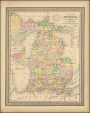
Detailed and interesting map of Michigan, hand colored by county and showing towns, rivers, bays, lakes, railroads, roads, distances, etc. Tables of Steam Boat routes and distances. A nice example of this increasing difficult to obtain map, from an early edition of the Thomas Cowperthwait version of Mitchell's Universal Atlas.