


|
||

|

|
|

|
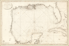
Important early chart of the Gulf Coast and Florida, issued in the 9th Year of the the French Revolution (An. IX.)
The map was issued one year after the Spanish Carta Esferica and draws extensively from this map. This landmark mapping of Texas, Florida and the Gulf Coast, is based upon the 1799 Carta Esferica, the first large-scale printed chart of the Texas Coast based upon actual soundings and explorations. The map is based in large part on the landmark survey of the coast commissioned by Bernardo de Galvez and conducted by Jose de Evia. The most significant milestone of the survey was the discovery of Galveston Bay in 1785, which had never before appeared on a printed map. Baie de Calvesion (Galveston) is shown on the present map exactly as laid down in the manuscript maps from Evia's Survey. The coastline configuration in the Carta Esferica established the prototype for the mapping of Texas and the U.S. Gulf Coast which would dominated printed maps for the next 2 decades.
The map remained as one of the most significant charts of the region for several decades. Both Humboldt and Arrowsmith copied the information set forth in this map for their important maps. The present exampel has several minor repaired tears and modern wash coloring. The sailing ships are added in manuscript, an interesting embellishment to this important map.
The Dépôt de la Marine, known more formally as the Dépôt des cartes et plans de la Marine, was the central charting institution of France. The centralization of hydrography in France began in earnest when Jean-Baptiste Colbert became First Minister of France in 1661. Under his watch, the first Royal School of Hydrography began operating, as did the first survey of France’s coasts (1670-1689). In 1680, Colbert consolidated various collections of charts and memoirs into a single assemblage, forming the core of sources for what would become the Dépôt.
The Dépôt itself began as the central deposit of charts for the French Navy. In 1720, the Navy consolidated its collection with those government materials covering the colonies, creating a single large repository of navigation. By 1737, the Dépôt was creating its own original charts and, from 1750, they participated in scientific expeditions to determine the accurate calculation of longitude.
In 1773, the Dépôt received a monopoly over the composition, production, and distribution of navigational materials, solidifying their place as the main producer of geographic knowledge in France. Dépôt-approved charts were distributed to official warehouses in port cities and sold by authorized merchants. The charts were of the highest quality, as many of France’s premier mapmakers worked at the Dépôt in the eighteenth century, including Philippe Bauche, Jacques-Nicolas Bellin, Rigobert Bonne, Jean Nicolas Buache, and Charles-François Beautemps-Beaupré.
The Dépôt continued to operate until 1886, when it became the Naval Hydrographic Service. In 1971, it changed names again, this time to the Naval and Oceanographic Service (SHOM). Although its name has changed, its purpose is largely the same, to provide high quality cartographic and scientific information to the France’s Navy and merchant marine.
![[Jefferson's Notes on the State of Virginia] Observations sur la Virginie [with the map:] A Map of the country between Albemarle Sound, and Lake Erie, comprehending the whole of Virginia, Maryland, Delaware, and Pensylvania, with parts of several other of the United States of America. Engraved for the Notes on Virginia.](https://storage.googleapis.com/raremaps/img/small/51828.jpg)
![[Caribbean]](https://storage.googleapis.com/raremaps/img/small/85443.jpg)
![A Description of Western Texas, Published by the Galveston, Harrisburg & San Antonio Railway Company, the Sunset Route [with map:] Correct Map of Texas Published by Galveston, Harrisburg & San Antonio Railway](https://storage.googleapis.com/raremaps/img/small/86207.jpg)
![Mexico [with Southwestern U.S., Texas, etc.]](https://storage.googleapis.com/raremaps/img/small/97606.jpg)