|
||

|

|
|

|
One of the earliest obtainable maps to show the new location of the University of California.
The history of the Univeristy of California and the City of Berkeley are inextricably intertwined. Formally established in 1878 as the merger of two communities, West Berkeley and Ocean View, the catalyst for Berkeley's growth was clearly the University. Founded as the College of California in 1855, by Henry Durant, its Board of Trustee's had great ambitions to create a world class university in the style of Harvard and Yale.
As early as 1857, Henry Durant was inspecting the Orrin Simmons farm, 4 miles north of the original campus in Oakland, near of Strawberry Creek. Ultimately, the college bought the Simmons farm for $35,000. In 1860 the trustees joined Willey and Durant at a rock outcrop for a ceremony dedicating the new campus. That ceremonial site, now at the northeast corner of the campus, has ever since been known as Founder's Rock.
By 1864 the college had obtained some additional parcels adjacent to the Simmons property but had no funds to pay for the move from Oakland. The trustees established the College Homestead Association, in effect a wholly-owned subsidiary which would subdivide and sell the land south of the property specifically reserved for the campus, in order to pay for the move. The new community was to be upscale, populated by solid citizens, living in the refined atmosphere of a college town. The trustees hired Frederick Law Olmsted, designer of New York's Central Park, to plan the development, but his ideas turned out to be too radical.
In 1873, several Ocean View businessmen, including Jacobs and A.A. Rammelsburg, joined with former University of California president Henry Durant, to create the Berkeley Land and Town Improvement Association. The association's purpose was to promote the development of West Berkeley, as Ocean View was increasingly coming to be called. The group laid out streets on a grid plan, subsidized a short-lived ferry service to San Francisco and publicized and promoted their community as a business location.
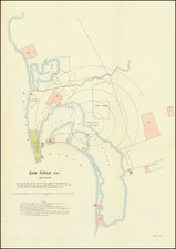
The upper map shows an 8 block area, bounded by Shattuck, Rose, Ceder and Arch Streets and a promotion for a sale of 260 lots land by auction on November 6, 1874 (on liberal credit). The lower map shows Berkeley, the University Campus, the land of the Berkeley Land & Town Assocation and the major connecting routes to Oakland, including Telegraph Avenue, Regent or Adeline Street and San Pablo Avenue. The Oakland Trotting Park and Deaf & Dumb Assylum also appear, as does Haywood & Jacobs Wharf and New Wharf. The only example of this map to appear in a public collection in California is the copy at the Bancroft Library. The map, which was published several months prior to the November sale, is one of the earliest obtainable maps of Berkeley and pre-dates the first rail service to the UC Campus. Only one other example located (Bancroft Library, UC Berkeley). Not in the California State Archives.
![Parts of E. California and S. E. Nevada, N.W. Arizona and S.W. Utah __ Atlas Sheet No. 66 [Shows Las Vegas!]](https://storage.googleapis.com/raremaps/img/small/92030.jpg)
![[ Baja California ]](https://storage.googleapis.com/raremaps/img/small/85440.jpg)