


|
||

|

|
|

|
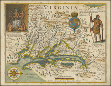
Flawless example of John Smith's map of Virginia which accompanied the 13th part of De Bry's Grand Voyages, published by Matheus Merian (De Bry's son-in-law). This edition of the map is a derivative of th 6th state of Smith's map, with very minor alternations to the decorative embellishments. The first six editions are very rare, pre-dating the appearance of the map in Purchas. Among the editions of the Smith map issued by Merian, this edition is perhaps the scarcest. Smith's map was by far the most important map of Virginia published in the first part of the 17th Century. First issued in 1612, it became the prototype map of the region until Augustine Hermann's map of 1673. First published seperately in London, the map later illustrated a number of rare works on Virginia and was instrumental in creating interest in the new Virginia Colony. The map records 166 Indian Villages, and is to this day source material for native American Archaeologists. In 1606, the London Company sent its first ship to Virignia and established the Jamestown settlement. Among the passengers was Captain James Smith, who would explore the region and create this map, which upon his return to London he had engraved by William Hole in 1612. The map depicts a number of explorations and observations of Smith and the Jamestown settlers. There is some question as to whether the map is the work of Smith (who led most of the explorations) or Nathaniel Powell (who was a surveyor). The map's illusrations derive from drawings by John White. Because this map was bound into a book, it is rarely found in good condition, making this example, which is essentially in flawless condition with nice wide margins, an extraordinary example. Burden 219.

![[ Pictish Warrior Woman ] Feminae Pictae icon V](https://storage.googleapis.com/raremaps/img/small/99648.jpg)