This item has been sold, but you can enter your email address to be notified if another example becomes available.


|
||

|

|
|

|
Stock# 11330
Description
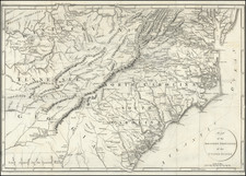
Detailed and interesting map of Kentucky, hand colored by county and showing towns, rivers, lakes, railroads, roads, distances, forts, etc. Tables of Steam Boat routes and distances. Large insets of area around Lexington, the Washington and Clarksburg area and the Falls of Ohio, including Jeffersonville, Louisville, Shippingport and Portland. Tanner's maps are now rare on the market.


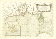
![[Florida and Gulf Coast] The Coast of West Florida and Louisiana . . . [with] The Peninsula and Gulf of Florida or Channel of Bahama with the Bahama Islands . . .](https://storage.googleapis.com/raremaps/img/small/66344.jpg)