|
||

|

|
|

|
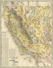
Interesting large format map of Southern California, hand colored by counties.
Many early counties not yet present, including Orange, Riverside and Imperial. While ostensibly a railroad map, the only railroads are in Santa Clara, Monterrey and Los Aglees Counties.
Even San Diego lacks rail service.
Asher & Adams was a New York publishing firm known for their atlases. Notably, their maps were some of the first to prominently exhibit railroad lines, even if this meant a slight reduction in topographical detail. They specialized especially in state and county maps of the United States.
Asher & Adams was a New York publishing firm known for their atlases. Notably, their maps were some of the first to prominently exhibit railroad lines, even if this meant a slight reduction in topographical detail. They specialized especially in state and county maps of the United States.
![The Mother Lode of California [Guide to the Mother Lode Mariposa to Downieville]](https://storage.googleapis.com/raremaps/img/small/97535.jpg)
![[ California Missions ] El C. Valentin Canalizo General De Division, Gobernador y Comandante General del Departmento de México [Mexico: Aug. 23, 1843]](https://storage.googleapis.com/raremaps/img/small/101827.jpg)
![[Austins Colony] Mexico & Guatemala](https://storage.googleapis.com/raremaps/img/small/94054.jpg)
![[Santa Cruz / Holmes Lime Company] [H.T. Holmes Lot. Area 15 85/100 Acres.](https://storage.googleapis.com/raremaps/img/small/76542.jpg)