|
||

|

|
|

|
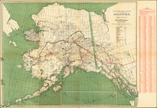
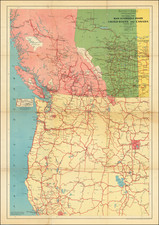
Mapping The White Pass & Yukon Route
The Map of White Pass & Yukon Route and Connections, dated 1917, provides a detailed illustration of the transportation networks spanning Alaska, the Yukon Territory, and parts of British Columbia. This map, a product of early 20th-century cartography, showcases the essential routes that facilitated the movement of people and goods during a significant era of exploration and development in North America's northwestern frontier.
The White Pass & Yukon Route (WP&YR) was established during the Klondike Gold Rush of the late 1890s, serving as a critical infrastructure development that connected the port of Skagway, Alaska, to Whitehorse in the Yukon Territory. This narrow-gauge railway, which traversed some of the most challenging terrains in North America, was completed in 1900 and became a vital artery for miners and settlers seeking fortune and opportunity in the Yukon.
By 1917, the WP&YR had solidified its role not only as a transportation route for gold prospectors but also as a conduit for the broader economic activities that followed the initial rush. The map highlights the network's connections with other transportation modes, including steamship lines and stage routes, emphasizing the integrated system that supported the region's growth and development.
The map prominently displays the main WP&YR railway line, depicted with a distinctive symbol, traversing from Skagway through the mountainous White Pass, past Bennett Lake, and onward to Whitehorse. This route is essential for understanding the logistical challenges and engineering feats achieved during the railway's construction. The following transit lines are shown.
- Railway Lines of White Pass & Yukon Route
- Steamer Lines of White Pass & Yukon Route
- Steamer Lines of American-Yukon Navigation Company
- Nome-Seattle Steamship Lines
- Southeastern and Southwestern Alaska Steamship Lines
- Winter Stage Line to Dawson (Can. Govt. Trail)
- Richardson Highway (U. S. Govt. Winter Trail)
Atlin Lake District
The inset map in the top right corner focuses on the Atlin Lake District, an area of considerable mineral wealth and subsequent mining activity. This inset provides a closer look at the local routes and trails that connected mining camps and settlements, illustrating the region's economic significance.