|
||

|

|
|

|
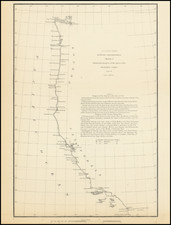
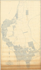
Early-20th-century photostat of an important U.S. Army Corps of Engineers manuscript map of Southern California, prepared by Edward Trapp in 1869. The maps covers the area from Camp Mojave (now Fort Mohave) and the ghost town of Hardyville in the northeast, to Fort Yuma in the southeast, San Diego in the southwest, and the Kern River in the northwest.
The late 1860s were a time of keen interest in establishing railroad connections into Southern California, but the focus of this map is on the military installations in the Mojave and Colorado Deserts, namely Fort Yuma, Camp Colorado "(Temporary)", Camp Mojave, and Camp Cady.
Ten years before this map was made, the region underwent the so-called Mojave War.
A noteworthy record of early roads and distances in Southern California.
Rarity
The original manuscript on which this map is based is held in the National Archives. OCLC records UCLA and UC Berkeley as holding photostats.
Provenance
Colonel George Ruhlen (1884-1971), noted Southern California historical geographer.