|
||

|

|
|

|
A Fantastic Impression of the First State of the Grandest of All London Maps
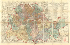
John Rocque's 1746 Map of London, Westminster, and Southwark, commonly referred to as the 24-sheet map, represents a monumental achievement in the field of cartography. This mammoth plan, officially titled A Plan of the Cities of London and Westminster, and Borough of Southwark, is an intricately detailed depiction of Georgian London. It was conceived as a response to the city's rapid expansion since the last significant map by John Ogilby and William Morgan, published in 1676, following the Great Fire of London. The map was surveyed by Rocque himself and engraved by John Pine, measuring a substantial 12.6 by 6.6 feet. The creation of this masterpiece took almost a decade and is lauded as 'a magnificent example of cartography' and 'one of the greatest and most handsome plans of any city.'
The coverage of Rocque's map is both expansive and meticulous, extending from Knightsbridge and the Serpentine in the west to just shy of Canary Wharf in the east. This range encapsulates the very heart of London, taking in the bustle of the City and the elegance of the West End. In the south, the map reaches down to Elephant and Castle, including what are today the vibrant, multicultural communities of South London. To the north, the map stretches up to the districts of Marylebone and Clerkenwell, taking in the grand townhouses, tranquil garden squares, and the burgeoning commercial and industrial establishments of the time. This geographical span underscores the map's value as a comprehensive representation of mid-eighteenth-century London, showcasing both the wealth and breadth of the city's urban landscape.
Surveying the Map
Rocque's method of surveying for this map combined two techniques: ground-level surveying with a compass and metal chain for measuring lengths, and triangulation via readings from prominent high points, such as church towers, using a telescopic-sighted theodolite made by Jonathan Sisson. This approach required careful reconciliation between the two techniques, as there were discrepancies between the more accurate triangulation and the initial ground surveys.
John Rocque (circa 1704-1762), an 18th-century surveyor of Huguenot descent, left a profound imprint on the topographical representation of England, particularly through his elaborate maps of London and its surroundings. Despite his significant contributions, his life, both personally and professionally, remains somewhat cloaked in mystery.
Born likely around 1704 or 1705 to French Huguenot parents who migrated to Geneva following the revocation of the Edict of Nantes, Rocque found his calling in England. There, he and his siblings were known to have spent significant parts of their lives. His journey into surveying took off in 1734, with his first recognized work involving a survey of Richmond House and its gardens. This engagement emerged at a fortuitous time when the landscaping and design of the nobility's estates were witnessing renewed interest, which required accurate surveying—a skill Rocque exemplified.
Rocque didn't confine his talents to surveying alone but ventured into printselling, owning a shop near Hyde Park Corner by 1743. This enterprise reflected his energetic nature and the breadth of his ambition, contributing to his reputation for high-quality work, evidenced by the size of his workforce, which included up to ten draughtsmen and engravers at times.
In his later years, Rocque faced adversity, with his shop and entire stock in Whitehall being devastated by fire in 1750. However, his resilience saw him bounce back, and despite several relocations, Rocque maintained his business operations around the Strand area. By the 1750s, his work had taken him to Dublin, where he made substantial contributions in the form of numerous Irish maps and various English county maps.
On the personal front, Rocque married twice but had no known children from either marriage. His first wife was Marthe, whom he married by 1728, and following her death, he married Mary Anne Bew in 1751. Rocque's health began deteriorating towards the end of his life, leading to his death on January 27, 1762. His widow, Mary Anne, continued to manage the business for several years after his demise.
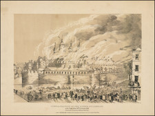
![(The Valentine Knight Plan of London ] Several Propositions and Schemes were offer'd to rebuild the City of London after the great Fire in 1666. This was the one propos'd by Val. Knigh, printed 20th of September 1666, without any Draught or Delineation by this Sketch now done, it may be easily compared with other Designs printed.](https://storage.googleapis.com/raremaps/img/small/80972.jpg)
![Regionis, quae est circa Londinum specialis repraesentatio geographica, ex autographo majori Londinensi . . . 1741 [Includes Bird's-eye View of London and Westminster]](https://storage.googleapis.com/raremaps/img/small/95041.jpg)