|
||

|

|
|

|
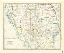
The First Atlas Map of West Texas
Interesting large format map of Western Texas, hand colored by counties, from Asher & Adams' Atlas of the United States.
Published at a time when West Texas was something of a Terra Incognita to all but the heartiest travelers, this is the first atlas map to focus on the Western portion of Texas, which is still dominated by a massive Bexar County and Presidio County.
The course of the Texas & Pacific R.R. is shown on both the main map and passing through El Paso Count in the large inset, an early depiction of its route. The Texas & Pacific Railway (T&P) was a pivotal force in the economic development of Texas and the Southwest, embodying the rapid expansion of the railroad industry in the United States during the late 19th century. It was chartered by the United States Congress in March 1871, with the ambitious goal of forging a transcontinental route that would bridge the southern states and connect Marshall, Texas, to San Diego, California.
The enterprise drew significant attention and investment, notably from financial magnate Jay Gould in the 1870s, who envisioned the T&P as a critical component of his burgeoning railroad empire. Gould's involvement provided essential capital and political influence, though his overarching ambitions often led to complex financial maneuvers that drew scrutiny and controversy.
Construction commenced from both termini—eastward from Marshall and westward from San Diego. The endeavor faced numerous challenges, including financial difficulties that were exacerbated by the Panic of 1873, a major economic downturn that stalled progress. Despite these setbacks, the Texas & Pacific pushed forward, reaching significant milestones such as the connection to Dallas in 1873 and Fort Worth in 1876.
The T&P never reached San Diego. Its westernmost reach was halted at Sierra Blanca in West Texas in 1881. That same year marked a crucial development: under the direction of Gould, the T&P was absorbed into the Missouri Pacific Railroad, another arm of his transportation network. This merger did not impede the T&P's role in regional development; instead, it expanded its influence by facilitating trade and migration throughout the Southwest.
The legacy of the Texas & Pacific Railway is marked by its vital role in the settlement and economic development of Texas. It not only spurred the growth of cities along its routes, such as Fort Worth and El Paso, but also played a critical part in the agricultural and industrial markets by providing necessary transportation infrastructure. The railway's history reflects both the transformative impact of railroads on America's economic landscape and the complex interplay of finance, politics, and physical endeavor that characterized the era’s railroad expansion.
Asher & Adams was a New York publishing firm known for their atlases. Notably, their maps were some of the first to prominently exhibit railroad lines, even if this meant a slight reduction in topographical detail. They specialized especially in state and county maps of the United States.
Asher & Adams was a New York publishing firm known for their atlases. Notably, their maps were some of the first to prominently exhibit railroad lines, even if this meant a slight reduction in topographical detail. They specialized especially in state and county maps of the United States.


![Texas [The Rand McNally Vest Pocket Map of Texas]](https://storage.googleapis.com/raremaps/img/small/86827.jpg)