|
||

|

|
|

|
Nice example of first state of Esnaut & Rapilly's rare separately issued map of the British Colonies in North America, published in Paris.
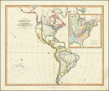
Fascinating large format map of the Theater of War in North America, in the midst of the American Revolution. The map extends from the eastern part of North America from the Hudson Bay to the Gulf of Mexico, extending westward as far as modern-day Galveston. Esnauts & Rapilly first issued the map in 1777, with Phelippeaux and Brion de la Tour re-issuing the map with a different title and minor revisions in 1778 and 1779, following the signing of the Treaty of Alliance between France and the fledgling United States, which brought the American Revolutionary effort to the attention of the French public.
The map draws from John Mitchell's landmark map of 1755. It presents the colonies in superb detail, identifying cities and towns, forts, roads, Indian villages and tribal territory. Curiously, this map attempts to offer both a French and an English mapping of the region. French Louisiana extends eastwards as far as the Appalachian Mountains and westward well into territories claimed by Spain but shows the original British Colonial grant for Virginia and Carolina grant, extending westward to the edge of the map. The fact that Louisiana west of the Mississippi had been ceded to Spain following the French and Indian War does not seem to be acknowledged. What is acknowledged is the cession of Upper Louisiana, north of 40 degrees latitude and east of the Mississippi, to the British, under the 1763 Treaty of Paris. This important treaty effectively gave the British control of the lucrative fur trade in the upper Mississippi Valley and eventually gave rise to the North West Company and the era of the Mountain Men in the early years of the 19th century.
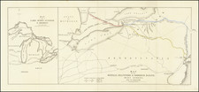
This map also depicts the Great Lakes in a curious fashion. In Lake Superior, the islands first shown on Bellin's 1744 map were later shown by Mitchell and are present. Following the Revolutionary War, the 1783 Treaty of Paris used the islands to form the official border between the United States and Canada, including a reference to these islands ("by Lake Superior north of the islands and royal Phelipeaux to Long Lake"). It was not until the official U.S. - Canada border surveys of 1820 that the existence of these islands was finally brought into question.
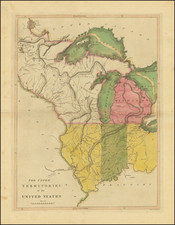
The map also depicts numerous Native American settlements, roads and early settlements, as well as French Forts in Louisiana and along the Mississippi River.
Texas is called the "Pays de Cenis," referring to the Cenis tribe which, from the 16th through the 18th centuries, was one of the largest and most powerful tribes in the American southwest. Known for their hospitality towards European travelers, the Cenis are remembered for amicably hosting La Salle, Onate, Coronado, and other early explorers. In fact, in the Cenis language the word for welcome is "Techas, Techas", meaning "friend". Eventually "Techas" became known as "Tejas" and, in time, "Texas". With the French and subsequent American settlement of Louisiana, as well as the exodus of the Natchez and Chocktaw from Alabama, the Cenis were confined to a smaller and smaller territory surrounding the Trinity (Trinidad) River - as their villages are shown here. Eventually the remaining Cenis and a large group of emigrating tribes met in a great battle on the Bank of the Trinity in which the Cenis nation was utterly destroyed.
States of the Map
State 1 (1777): Title is Carte Detaillee Des Possessions Angloises dans l'Amerique Septentrionale. The details of George Washington's success at the Battle of Trenton (December 26, 1776) have not yet been added.
State 2 (1778): Title changed to Carte Generale des Colonies Angloises Dans L'Amerique Septentrionale. . . . The map is now attributed to M. Phelippeaux, Ingenr-Geographe as a continuation of Brion de la Tour's Theatre of War. Three picket fence like symbols have been added nearly Trenton on the north side of the Delaware River, likely referencing Washington's successful 3 pronged attack on Hessian forces under General Johann Rall at the Battle of Trenton. Similarly, four picket fense symbols have been added near "Sarahatogal" and "Sacheudago", centered on Lake Saratoga, reflecting the Battes of Saratoga (September 9, 1777 and October 7, 1777). Map also now includesa a a price of 1tt. 10f (bottom of title).
State 3 (1779): Date changed to 1779, but title is otherwise unchanged.
State 4 (1781): Date changed to 1781 but title is otherwise unchanged. A note is now added regarding the surrender of Cornwallis at York and Gloucester (see below).
À York et Gloucester, le Général CORNWALLIS a été fait prisonnier avec son armée par les Américains et les Français, aux ordres des Généraux Washington et Rochambeau le 19 Octob 1781.
Translation:
At York and Gloucester, General CORNWALLIS was taken prisoner along with his army by the Americans and the French, under the command of Generals Washington and Rochambeau on October 19, 1781.
Rarity
All states of the map are very rare on the market.
This is the second time we have offered the map for sale, with the last example being a de-accession from Colonial Williamsburg.