|
||

|

|
|

|
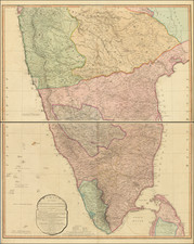
Important Early Mapping of the Himalayas By An Early British Mountaineer and Explorer
The World's Longest Glacial System Outside The Polar Regions
Fine early map of a portion of the glacial Himalaya Mountains, delineating the formidable around the Hispar Glacier, as charted in 1892 by the distinguished explorer W. Martin Conway. Drawn from Conway's original drawings, presents a richly detailed topography of one of the Earth's most challenging and least accessible landscapes.
The confluence of the Biafo Glacier and the Hispar Glacier creates the world's longest glacial system outside of the polar regions.
In an era when the reaches of the Himalayas were only beginning to be understood by the Western world, Conway's work represented a significant advancement in the geographic and topographic knowledge of the region. Conway led an expedition under the auspices of the Royal Society, the Royal Geographical Society, and the British Association to the Karakoram range. During this expedition, he ascended a subsidiary summit of Baltoro Kangri, initially claiming a world altitude record of 23,000 feet, though this was later revised to 22,322 feet. His mappings of the Karakoram range, specifically the Bagrot, Hunza, and Nagyr valleys alongside the extensive Hispar Glacier, provided valuable insights into the geography and potential routes through this monumental mountain range.
The map's visual representation is striking, with shaded relief depicting the rugged mountainscape, and contour lines conveying the formidable elevations. This detailed cartographic work is not only a testament to the skill of its creator but also serves as a historical record of the landscape as it was perceived at the turn of the century. The use of color and meticulous attention to topographical detail underscore the daunting nature of the Himalayan environment.
This document's significance is amplified by its role in the broader historical context of exploration. The late 19th century witnessed the convergence of scientific expeditions and imperial ambitions, and Conway's surveys were instrumental in the quest to comprehend and navigate the challenging frontiers of the British Empire. It encapsulates the spirit of an age that sought to document and understand the natural world through empirical observation and scientific technique.
Edward Stanford (1827-1904) was a prominent British mapmaker and publisher. A native of Holborn in the heart of London, Edward was apprenticed to a printer and stationer at the age of 14. After his first master died, he worked with several others, including Trelawny W. Saunders of Charing Cross. Saunders oversaw young Edward’s early career, ensuring that he became a Fellow of the Royal Geographical Society. Associations with the Society eventually brought Sanders much business and gave him a reputation as a publisher of explorers. As testament to this reputation, the Stanford Range in British Columbia was named for him by John Palliser.
Stanford briefly partnered with Saunders in 1852 before striking out on his own in 1853. He was an agent for the Ordnance Survey, the Admiralty, the Geological Survey, the Trigonometrical Survey of India, and the India Office. He also controlled the maps of the Society for the Diffusion of Useful Knowledge, another lucrative source of income. In 1857, Stanford founded his namesake Geographical Establishment, with Saunders and A. K. Johnston as engravers. Thereafter, Stanford was known for his “library maps”, particularly those of Africa and Asia.
Addresses and Years of Operation:
- 6 Charing Cross, London (1848): Edward Stanford's initial place of employment at Trelawney Saunders' shop.
- 7 and 8 Charing Cross, London (1853): Stanford expanded his shop to these addresses.
- 55 Charing Cross, London (1873): The shop moved to this larger location.
- 12-14 Long Acre, London (1873): Site of the new print works and current flagship store.
- 7 Mercer Walk, London (2019): Stanfords moved to this address, continuing its legacy.
Stanford's work with Chief Cartographer John Bolton, including the 1858 Library Map of Europe, positioned the company as a leader in quality cartography during a time of exploration and colonialism. Their 1862 Library Map of London earned acclaim from the Royal Geographical Society. With the business thriving, Stanford purchased Staunton & Son in 1877 and, upon retiring in 1885, handed over the reins to his son, Edward Stanford II.
As sole agents for Ordnance Survey Maps, the company's influence and reputation grew, culminating in the Stanford’s London Atlas Of Universal Geography, which was presented to Queen Victoria in 1887. The transition into the 20th century saw further integration of retail, print, and cartographic operations at Long Acre.
During World War I, Stanford's became an essential publisher for the War Office. Edward Fraser Stanford took over in 1917, steering the company through the interwar period and innovations, such as the world’s smallest maps in 1922 and the Daily Mail Motor Road Map in 1926.
Withstanding a bombing in WWII, the company continued under the stewardship of John Keith Stanford and was sold to George Philip & Son in 1947. As it adapted to the digital age, Stanfords received the Ordnance Survey Premier Partner status in 2007 and ventured into online mapping and data services.
Stanfords, now an icon for travellers and explorers, has maintained its cultural relevance and retail success well into the 21st century, underpinned by a legacy of entrepreneurial spirit and commitment to cartographic excellence.
![[Nepal] Latest Trekking Map North North of Jomsom Jomsom to Mustang](https://storage.googleapis.com/raremaps/img/small/44106.jpg)