|
||

|

|
|

|
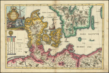
Hand Drawn Plan of the Siege of Wismar in 1675
Detailed plan of the town and fortifications of Wismar, a Hanseatic League city on the Baltic Sea, illustrating the town at the time of the December 13, 1675, siege.
This meticulous 17th-century map captures the siege of Wismar, which lasted from the December 13 to December 15, 1675, during the Scanian War, marking a pivotal event wherein King Christian V of Denmark successfully besieged the fortified town. North is strategically oriented to the top, offering a precise representation of the siege’s dynamics.
The map includes fortified positions in the north, southeast and west, with Lieutenant General Niels Rosenkrantz is shown in the east and Major General Schaken to the south identified.
The Scanian War, part of the larger Northern Wars, was fought over territory in the Scanian region and Northern Germany, reflecting the complex alliances and conflicts of European powers in the late 17th century. This conflict saw Denmark–Norway, Brandenburg, and Sweden embroiled in a power struggle exacerbated by Swedish engagement in the Franco-Dutch War. The map not only represents a moment in this regional conflict but also the broader geopolitical chessboard of Europe at the time.
The Danish incursion into Scanian lands aimed to reclaim territories lost to Sweden in the Treaty of Roskilde. The Danish initial successes were met with vigorous Swedish resistance, leading to a stalemate and eventual peace treaties. The map thus encapsulates a moment of Danish triumph, yet also presages the transient nature of military conquests during this period.