|
||

|

|
|

|
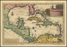
Extremely rare first state of Colom's rare map of the Southeastern US, Gulf Coast, Central America and the Caribbean.
The map is drawn loosely from prior maps by Hessel Gerritsz and Theunis Jacobsz, with the nomenclature of North America following the Jacobsz very closely, except for the naming of the Cheapeake Bay (Chesape) and the addition of R. Gironde below Port Royal. The map adds internal detail to a number of the rivers previously shown on the Jacobsz. The detail along the East Coast of North America and the Gulf Coast are noteworthy, with many early place names. Burden surmises that the map was published in approximately 1656, as the second state of the map bears this date in the title cartouche. A fascinating note about Bermuda is shown in both English and Dutch at the top of the map. Burden locates only one example in an institutional collection.

![[First Sea Chart of New Netherlands] Pascaarte van Nieu Nederlandt uytgegeven door Arnold Colom](https://storage.googleapis.com/raremaps/img/small/46535.jpg)
![[Revolutionary War Plans of New York, Boston, Charleston, Delaware River to Philadelphia & Havana] Various Plans and Draughts of Cities, Towns, Harbours &c . . .](https://storage.googleapis.com/raremaps/img/small/83450.jpg)