|
||

|

|
|

|
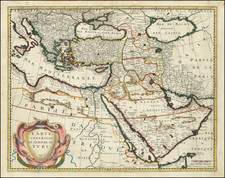
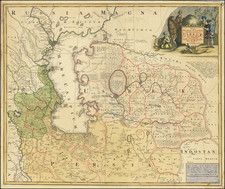
The First Map of What is Now Pakistan and Afghanistan Published Outside of Italy.
This fantastic woodcut map of Pakistan and Afghanistan was prepared for Leinhardt Holle in Ulm, Germany in 1482. The present example adds the title ("Nona Asie Tabula") across the top denoting it as the ninth Ptolemaic map of Asia and was published in Ulm in 1486 by Johann Reger.
The map is bounded by the Indus River ("Indus fluuius") and includes a patchwork of Classical kingdoms as they were understood to exist during the 2nd century.
Aria, or Ariana, was located in what is now western Afghanistan and eastern Iran. It was a region known for its fertile land and strategic location along the Silk Road, facilitating trade between the East and West. It was an important province of various empires, including the Persian Empire and Alexander the Great's empire.
Paropanisus corresponds to the area around the Hindu Kush mountains, primarily in present-day Afghanistan. It was known for its challenging mountain passes and served as a gateway for invaders and traders moving between Central Asia and the Indian subcontinent. It was also significant in the spread of Buddhism from India to Central Asia.
Drangiana, or Sarangia, was situated in the area of present-day Sistan in Iran and parts of Afghanistan, Drangiana was important for its location at the crossroads of trade routes leading to the Indian subcontinent, Persia, and Central Asia. It was known for agriculture and was a part of various empires, including the Achaemenid, Seleucid, and Sassanian empires.
Arachosia covers parts of modern-day southern Afghanistan and Pakistan; it was strategically located on the trade routes connecting India with the Persian Empire and beyond. Its capital, Kandahar, was historically significant for trade and military campaigns.
Gedrosia corresponds to the Makran coast of modern-day Pakistan and Iran, Gedrosia was known for its harsh desert landscape. Alexander the Great's army suffered significant hardships while crossing it. Despite its challenging geography, it was part of the trade routes linking the Middle East to the Indian subcontinent.
At the edges of the map, Carmanie Pars, or Kerman, is located in southeastern Iran. It was important for its position on the trade and military routes connecting Persia with the Indian Ocean. The area was known for its diverse geography, including desert and mountainous landscapes.
Finally, "Indie intra gangem fluvium pars" refers to the northern part of the Indian subcontinent, particularly the fertile Ganges Plain. It was known for its rich culture, advanced urban settlements, and as the birthplace of major religions such as Hinduism and Buddhism. The area was a crucial part of trade networks extending throughout Asia.
The Ulm Ptolemy of 1482 and 1486
The Ulm edition of Ptolemy was first published in 1482 by Lienhart Holle. In contrast to the two earlier illustrated editions of Ptolemy's geography - Bologna (1477) and Rome (1478) - the maps in the Ulm edition are woodblock prints, not copperplate engravings. The maps in the Ulm edition follow the manuscript maps of Donnus Nicolaus Germanus, a Benedictine monk from Breslau who produced brilliant presentation copies for Italian elites in the 1460s and 1470s. Specifically, the Ulm was patterned after the manuscript atlas prepared for Pope Paul II. The Ulm Ptolemy was the first book Holle published, but it was also to be one of his last. Holle went bankrupt shortly after the original publication. The work was then taken over by Johann Reger, who issued another edition in 1486.
The differences between the two editions are relatively small. The 1486 maps typically include titles at the top, whereas there were no titles on the 1482 maps. An unpublished study of the individual maps reveals that there are multiple states of most of the maps.
It had long been suggested that the way to differentiate between the 1482 and 1486 editions was the use of lapis lazuli blue in the 1482 edition for the seas, whereas the 1486 used brown. However, the same unpublished study, which evaluated dozens of examples of the two editions, determined that the earliest examples of the 1486 were also issued with the lapis lazuli blue, suggesting that when Johann Reger acquired the woodblocks, he likely also acquired some unused lapis lazuli. In 2021, we offered for sale a complete example of a 1486 entirely in lapis lazuli blue.
Claudius Ptolemy (fl. AD 127-145) was an ancient geographer, astronomer, and mathematician. He is known today through translations and transcriptions of his work, but little is known about his life besides his residence in Alexandria.
Several of his works are still known today, although they have passed through several alterations and languages over the centuries. The Almagest, in thirteen books, discusses astronomy. It is in the Almagest that Ptolemy postulates his geocentric universe. His geometric ideas are contained in the Analemma, and his optical ideas were presented in five books known as the Optica.
His geographic and cartographic work was immensely influential. In the Planisphaerium, Ptolemy discusses the stereographic projection. Perhaps his best-known work is his Geographia, in eight books. However, Ptolemy’s ideas had been absent from western European intellectual history for roughly a thousand years, although Arab scholars interacted with his ideas from the ninth century onward.
In 1295, a Greek monk found a copy of Geographia in Constantinople; the emperor ordered a copy made and the Greek text began to circulate in eastern Europe. In 1393, a Byzantine diplomat brought a copy of the Geographia to Italy, where it was translated into Latin in 1406 and called the Cosmographia. The manuscript maps were first recorded in 1415. These manuscripts, of which there are over eighty extant today, are the descendants of Ptolemy’s work and a now-lost atlas consisting of a world map and 26 regional maps.
When Ptolemy’s work was re-introduced to Western scholarship, it proved radically influential for the understanding and appearance of maps. Ptolemy employs the concept of a graticule, uses latitude and longitude, and orients his maps to the north—concepts we take for granted today. The Geographia’s text is concerned with three main issues with regard to geography: the size and shape of the earth; map projection, i.e. how to represent the world’s curve proportionally on a plane surface; and the corruption of spatial data as it transfers from source to source. The text also contains instructions as to how to map the world on a globe or a plane surface, complete with the only set of geographic coordinates (8000 toponyms, 6400 with coordinates) to survive from the classical world.
![Colton's Turkey in Asia and the Caucasian Provinces of Russia [shows Cyprus]](https://storage.googleapis.com/raremaps/img/small/89048.jpg)