|
||

|

|
|

|
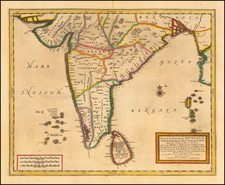
A Gorgeous Example of One of the Earliest Printed Maps of India - Printed 12 Years before Vasco da Gama reached India by sea.
This impressive woodcut map of India, printed in Ulm, Germany, in 1486, presents a Ptolemaic rendition of Classical India. "India Intra Gangem" is a Latin term that translates to "India within (or between) the Ganges" in English. This toponym historically referred to the regions of the Indian subcontinent that lie to the west of the Ganges River. This is in contrast to "India Extra Gangem" which was used to refer to Southeast Asia in Ptolemaic cartography.
In the west, "indus flu" (i.e., the Indus River) is named and illustrated, and in the east, "ganges flu" (the Ganges River) is named and illustrated. In the south, the northern coast of Sri Lanka ("Taprobane insule pars") can be seen. Above the name "Caspiria regio" in northwest India is a city named "Indara"; this corresponds with “Indabara,” from the Prakrit “Indabatta.” This is Indraprastha, a city of the Kuru Kingdom, mentioned in the Mahabharata. Archeology places it at the location of the Old Fort, in Delhi.
In the north, India is bordered by several named territories, along with a rendition of the Himalayan Mountains (here labeled "Imaus mons").
Arachosia (here rendered as "Aracholia") is a historical region that corresponds to a territory in what is today southern Afghanistan, eastern Iran, and parts of Pakistan. In ancient times, it was known as a crossroads of various cultures and empires due to its strategic location along the trade routes connecting the Middle East, Central Asia, and the Indian subcontinent, including parts of the Silk Road.
The map also references the Paropamisus mountain range, also known as the Paropamisadae, which was located in the region that is now part of Afghanistan and surrounding areas. In ancient geography, Paropamisus was known for separating various territories and also serving as a strategic location along the Silk Road.
The Ulm Ptolemy of 1482 and 1486
The Ulm edition of Ptolemy was first published in 1482 by Lienhart Holle. In contrast to the two earlier illustrated editions of Ptolemy's geography - Bologna (1477) and Rome (1478) - the maps in the Ulm edition are woodblock prints, not copperplate engravings. The maps in the Ulm edition follow the manuscript maps of Donnus Nicolaus Germanus, a Benedictine monk from Breslau who produced brilliant presentation copies for Italian elites in the 1460s and 1470s. Specifically, the Ulm was patterned after the manuscript atlas prepared for Pope Paul II. The Ulm Ptolemy was the first book Holle published, but it was also to be one of his last. Holle went bankrupt shortly after the original publication. The work was then taken over by Johann Reger, who issued another edition in 1486.
The differences between the two editions are relatively small. The 1486 maps typically include titles at the top, whereas there were no titles on the 1482 maps. An unpublished study of the individual maps reveals that there are multiple states of most of the maps.
It had long been suggested that the way to differentiate between the 1482 and 1486 editions was the use of lapis lazuli blue in the 1482 edition for the seas, whereas the 1486 used brown. However, the same unpublished study, which evaluated dozens of examples of the two editions, determined that the earliest examples of the 1486 were also issued with the lapis lazuli blue, suggesting that when Johann Reger acquired the woodblocks, he likely also acquired some unused lapis lazuli. In 2021, we offered for sale a complete example of a 1486 entirely in lapis lazuli blue.
Claudius Ptolemy (fl. AD 127-145) was an ancient geographer, astronomer, and mathematician. He is known today through translations and transcriptions of his work, but little is known about his life besides his residence in Alexandria.
Several of his works are still known today, although they have passed through several alterations and languages over the centuries. The Almagest, in thirteen books, discusses astronomy. It is in the Almagest that Ptolemy postulates his geocentric universe. His geometric ideas are contained in the Analemma, and his optical ideas were presented in five books known as the Optica.
His geographic and cartographic work was immensely influential. In the Planisphaerium, Ptolemy discusses the stereographic projection. Perhaps his best-known work is his Geographia, in eight books. However, Ptolemy’s ideas had been absent from western European intellectual history for roughly a thousand years, although Arab scholars interacted with his ideas from the ninth century onward.
In 1295, a Greek monk found a copy of Geographia in Constantinople; the emperor ordered a copy made and the Greek text began to circulate in eastern Europe. In 1393, a Byzantine diplomat brought a copy of the Geographia to Italy, where it was translated into Latin in 1406 and called the Cosmographia. The manuscript maps were first recorded in 1415. These manuscripts, of which there are over eighty extant today, are the descendants of Ptolemy’s work and a now-lost atlas consisting of a world map and 26 regional maps.
When Ptolemy’s work was re-introduced to Western scholarship, it proved radically influential for the understanding and appearance of maps. Ptolemy employs the concept of a graticule, uses latitude and longitude, and orients his maps to the north—concepts we take for granted today. The Geographia’s text is concerned with three main issues with regard to geography: the size and shape of the earth; map projection, i.e. how to represent the world’s curve proportionally on a plane surface; and the corruption of spatial data as it transfers from source to source. The text also contains instructions as to how to map the world on a globe or a plane surface, complete with the only set of geographic coordinates (8000 toponyms, 6400 with coordinates) to survive from the classical world.
![[India] Tabula Asiae X](https://storage.googleapis.com/raremaps/img/small/89683.jpg)

![[Mumbai] Plan De Bombay et ses Environs](https://storage.googleapis.com/raremaps/img/small/75975.jpg)