|
||

|

|
|

|
Stock# 100488
Description
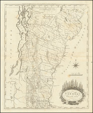
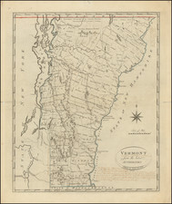
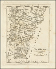
Nice example of Mathew Carey's small map of Vermont, which first appeared in Carey's American Pocket Atlas in 1796.
Extending from Lake Champlain and the Hudson River in the West to the Connecticut River, etc. the map is packed with early place names.
The map includes the names of the counties and townships of Vermont.
States of the Map
The map is known in 4 states:
- State 1 (1796): No roads. Most towns lacking the ° symbol.
- State 2 (1801): ° symbol added to most town names across the map.
- State 3 (1805): Ferrisburg has been renamed Fortsburg." The town symbol for Colchester has been moved inland, placed just below the C in Colchester. The road that ended at Jerico now continues to up through western Vermont to Huntsburg Plus other changes.
- State 4 (1813): Champlain, Chazyc and Platsburg have been added on western shore of Lake Champlain.
![[ Battle of Saratoga ] Plan of the Position which the Army under Lt. Gen. Burgoine took at Saratoga on the 10th of September 1777 and in which it remained till the Convention was signed.](https://storage.googleapis.com/raremaps/img/small/101239.jpg)
![[ Battle of Saratoga ] Plan of the Position which the Army under Lt. Gen. Burgoine took at Saratoga on the 10th of September 1777 and in which it remained till the Convention was signed.](https://storage.googleapis.com/raremaps/img/small/103578.jpg)