|
||

|

|
|

|
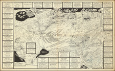
Rare Hayden Map Company Pictorial Map Centered on Mammoth Lakes District and the John Muir Trail
Highly detailed pictorial advertising and trail map of Mono County.
Oriented with southwest at the top, the map extends along US Highway 395 from Paradise Camp in the southeast, to the Yosemite area in the northeast, including Tuolumne Meadows, Tuolumne Pass, Tioga Pass and Mono Lake. A number of roads are located, along with lakes, mountains, rivers, small settlements, ranches, etc.
A key across the top locates the location of different types of fish and touts the duck hunting season. The map provides advertising for many of the area businesses, both tourist and non-tourist, including the local taxidermist.
The Hayden Map Co. promotion notes that they will soon complete maps of all the fishing and resort recreational areas within the 9 western states.
States of the Map and Rarity
There are two states of the map, both very rare.
The 1941 edition can be differentiated from the 1955 edition a follows:
- Lake Crowley covers a greater area in the 1941 edition, with the eastern portion of the lake extending past Chalk Bluff.
- In the 1955 edition Hayden extended map coverage to the northwest by approximately 4 miles and included Saddlebag Lake, perhaps to make room for additional advertisements.
- The 1955 edition shows a new road linking U.S. 395 in the vicinity of Birchim Canyon to a feeder road and following the Owens River Road.
- The 1955 edition no longer shows the road from rock creek Lake as extending along the Little Lakes Valley all the way to Lang Lake
- In the 1955 edition upper right contains a price for the map of 25 cents, the price not included in the earlier edition.
The Hayden Map Co
The Hayden Map Company was founded in the 1930s by Emmet Hayden. In 1927, Emmet Hayden procured a lease in the Inyo National Forest, where he built a four bedroom log cabin which is the Mammoth Lakes Museum today. Emmet was an Engineer, Surveyor, and Mapmaker by training. He put Mammoth Lakes on his 1934 map, titled "A Circle of Enchantment." Originally, the Hayden Map Company did sub-division work in the Los Angeles area. After moving to Mammoth Lakes for his summer residence, he had the idea of being a hunting and fishing guide, which became the Hayden Map Company. The two earliest maps were the "Three Flags Highway" and "The Circle of Enchantment."
![[Avalon / Catalina] Island Villa Villa Park and Las Casitas House Keeping Bungalows](https://storage.googleapis.com/raremaps/img/small/73382.jpg)