


|
||

|

|
|

|
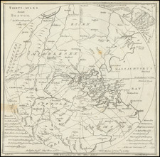
Facsimile edition of John Foster's map of New England, one of the most important early maps of America.
This is a lithograph facsimile of a most important map originally issued in 1677 to illustrate the London edition of William Hubbard's Present State of New England. Though seemingly crude in execution, the map was for its time the most advanced map of southern New England . This is reflected in the number of towns identified, the vertical lines indicating the northern and southern boundaries of the Massachusetts Bay Colony, and the relatively accurate depiction of Lake Winnipesaukee. The numbered towns are those that suffered from the depredations of the Indians during King Philip's War (1675-76).
Unlike most facsimiles, the present piece is important in its own right as a very early example of lithography in American mapmaking and probably the first map issued by the firm of Pendleton's in Boston. Pendleton's was established by John and William Pendleton in 1825 and became the first successful lithographic printer in the United States.
![[Battle of Lexington] Journee de Lexington . . .](https://storage.googleapis.com/raremaps/img/small/94722.jpg)