|
||

|

|
|

|
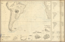
Rare English language privately printed chart of the coastal regions of parts of Peru and Bolivia, with a large inset Plan of the Port of Yquique and principal Mines of Guantajaya; with the roads from the Port.
The Remark on the map states:
This Plan, and also the Map of Tarapaca are drawn from Surveys, and by two officers of the Engl(ish) Mining Company of Potosi, the M.S.S. of which are brought to Europe by Dr. Meye in the H.M.S. Princess Louisa 1832, and deposted in the Royal Library, Berlin.
The Reference to Yquique is a mixture of sailing directions, description of the town and account of the neighboring mines:
. . . The anchorage is very tolerable as it is sheltered from the S.W. swell by the island but the Landing is bad and the way hazardous, owing to the number of blind breakers with which it abounds. The town of Yquique is a miserable place, that affords scarcely sufficient provisions for the consumption of its inhabitants, about 280 souls; no water nearer than Pizagua, a distce. of nearly forty miles, from which place it is brought by boats, and is very dear. Yet with these disadvantages, it is a place of considerable trade, from the quantity of salpetre, and the silver mines of Guantajaya: the latter are little marked, as the salpetre is a surer profit.
The note sounds similar to the observations made by Charles Darwin in July 1835, during his voyage on the Beagle, describing the town as "very much in want of everyday necessities, such as water and firewood". Darwin also visited the saltpeter works.
The chart is mentioned as having been used by James D. Dana in his Article On and Oceanic Chart, illustrating the Geographical Distribution of Marine animals, published in The American Journal of Science and A rts, Second Series (Vol 16; p166) 1853.
While we were noteable to locate any other examples of this map, we note the followng map which is referenced in Berghaus' correspondence with Alexander von Humboldt, a copy of which is noted in the Mapoteca Colombiana:
To His Excellency Baron Alexander Humboldt etc. This Chart of part of the coast of Peru between the parallels of 7° 35' and 14° South Latitude showing the thermometrical navigation of the il lustrious traveller from Callao towards Guayaquil and various passages of the Ships Louisa, King Frederick William III d Prince Royal of Prussia and Elisabeth Louisa of the Royal Prussian Mercantile Navy to, along and from these shores is inscribed with profound consideration and esteem by his most obliged and very humble servant Henry Bergbaus. Potsdam 1839.
![(Malaspina Expedition): [Group of six manuscript documents, signed, related to a future assignment for the officers of the Malaspina expedition, including a voyage to chart the coast of Guatemala and to explore Nicaragua, proposed by the viceroy of New Spain]](https://storage.googleapis.com/raremaps/img/small/101838.jpg)