


|
||

|

|
|

|
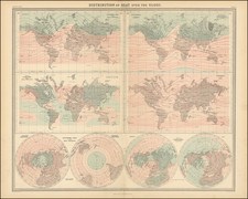
Striking example of Herman Moll's extraordinary 4-sheet map of the World on Mercator's projection, showing the routes of the explorers who had sailed in search of hte Northwest and Northeast Passages.
This spectacular map on Mercator's projection is one of the largest world maps ever produced for an atlas. The map shows the tracks of various explorers including Henry Hudson, Thomas James, Willem Barents and the circumnavigation of Woodes Rogers. Most of the Arctic is labelled "Parts Unknown," and the American West is largely conjectural, featuring California as an island. In Asia, "Iesso," or Hokkaido, is shown to be part of Siberia, and eastern Australia is not yet explorered.
The oceans within the Tropics of Cancer and Capricorn feature highly detailed hydrological information, most notably the direction of ocean currents, gleaned from Moll's esteemed contemporary Sir Edmond Halley. The inset to the upper left of the map features a diminutive world map depicting numerous lines of the degrees of compass variation. These calculations are, in part, based on measurements taken by Woodes Rogers during his transit across the Pacific, his individual readings being noted on the general map. An elegant circular inset in the lower left of the map depicts the Arctic regions as seen from directly above the Pole. This magnificent composition is further accentuated by the large title cartouche, which features personifications of the Old and New Worlds, enlivened by the most virtuous engraving.
The present map was part of Herman Moll's A
New and Compleat Atlas. Moll was the most important cartographer working in London during his era, a career that spanned over fifty years. Moll fled the turmoil of the Scanian Wars for London, and in 1678 is first recorded as working in London as an engraver for Moses Pitt on the production of the English Atlas. It was not long before Moll found himself as a charter member of London's most interesting social circle, which congregated at Jonathan's Coffee House at Number 20 Exchange Alley, Cornhill. It was at this establishment that speculators met to trade equities (most notoriously South Sea Company shares). Moll's coffeehouse circle included the scientist Robert Hooke, the archaeologist William Stuckley, the authors Jonathan Swift and Daniel Defoe, and the intellectually-gifted pirates William Dampier, Woodes Rogers and William Hacke. From these friends, Moll gained a great deal of privileged information that was later conveyed in his cartographic works, some appearing in the works of these same figures. Moll was highly astute, both politically and commercially, and he was consistently able to craft maps and atlases that appealed to the particular fancy of wealthy individual patrons, as well as the popular trends of the day. In many cases, his works are amongst the very finest maps of their subjects ever created with toponymy in the English language.
Herman Moll (c. 1654-1732) was one of the most important London mapmakers in the first half of the eighteenth century. Moll was probably born in Bremen, Germany, around 1654. He moved to London to escape the Scanian Wars. His earliest work was as an engraver for Moses Pitt on the production of the English Atlas, a failed work which landed Pitt in debtor's prison. Moll also engraved for Sir Jonas Moore, Grenville Collins, John Adair, and the Seller & Price firm. He published his first original maps in the early 1680s and had set up his own shop by the 1690s.
Moll's work quickly helped him become a member of a group which congregated at Jonathan's Coffee House at Number 20 Exchange Alley, Cornhill, where speculators met to trade stock. Moll's circle included the scientist Robert Hooke, the archaeologist William Stuckley, the authors Jonathan Swift and Daniel Defoe, and the intellectually-gifted pirates William Dampier, Woodes Rogers and William Hacke. From these contacts, Moll gained a great deal of privileged information that was included in his maps.
Over the course of his career, he published dozens of geographies, atlases, and histories, not to mention numerous sheet maps. His most famous works are Atlas Geographus, a monthly magazine that ran from 1708 to 1717, and The World Described (1715-54). He also frequently made maps for books, including those of Dampier’s publications and Swift’s Gulliver’s Travels. Moll died in 1732. It is likely that his plates passed to another contemporary, Thomas Bowles, after this death.
![De Schepping der Wereldt Volgens de Beschryving van Mozes. 1 Plaat [in set with] De Schepping der Wereldt Volgens de Beschryving van Mozes. 2. Plaat](https://storage.googleapis.com/raremaps/img/small/102641.jpg)
![[ Genesis / Creation ] De Schepping der Wereldt Volgens de Beschryving van Mozes. 1 Plaat [in set with] De Schepping der Wereldt Volgens de Beschryving van Mozes. 2. Plaat](https://storage.googleapis.com/raremaps/img/small/101543.jpg)
![[Early Photographic Facsimile of the Catalan-Estense World Map]](https://storage.googleapis.com/raremaps/img/small/66756.jpg)