![Belgii Pars Septentrionalis communi nomine Vulgo Hollandia…[Inset Views of New Amsterdam (New York City) & Batavia and Maps of NE United States and SE Asia] By Johann Baptist Homann](https://storage.googleapis.com/raremaps/img/small/78398.jpg)


|
||

|

|
|

|
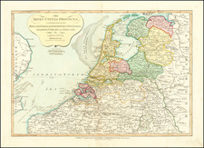
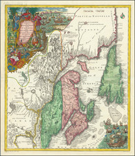
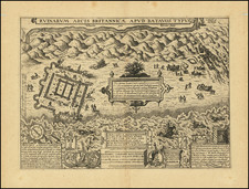
Nice dark impression of Homann's map of the Low Countries, with large inset maps of the Northeastern US (from the Chesapeake to Massachusetts) and Southeast Asia and vignette views of New Amsterdam (New York City) and Batavia.
A highly detailed map of the Low Countries, celebrating the Dutch Colonial controls over New York and the northeastern United States and of Southeast Asia, at the height of its trading strength. Shows towns, rivers, lakes, islands, lowlands, canals, etc. Large decorative allegorical cartouche.
One of Homann's earliest maps and the only Homann map to include a view of New York City.
Johann Baptist Homann (1663-1724) was a mapmaker who founded the famous Homann Heirs publishing company. He lived his entire life in Bavaria, particularly in Nuremberg. Initially, Johann trained to become a priest before converting to Protestantism and working as a notary.
In 1702, Johann founded a publishing house that specialized in engravings. The firm flourished, becoming the leading map publisher in Germany and an important entity in the European map market. In 1715, Johann was named Imperial Geographer to the Holy Roman Empire by Charles VI and made a member of the Prussian Academy of Sciences. Most importantly for his business, his reputation and contacts gained him imperial printing privileges which protected his publications and recommended him to customers. Johann is best known for this Grosser Atlas ueber die ganze Welt, or the Grand Atlas of the World, published in 1716.
After Johann died in 1724, the business passed to his son, Christoph (1703-1730). Upon Christoph’s early death, the company passed to subsequent heirs, with the name of the company changing to Homann Erben, or Homann Heirs. The firm continued in business until 1848.
![[ Holy Roman Empire ] A Newe Mape of Germany Newly Augmented by Iohn Speed Ano Dom: 1626](https://storage.googleapis.com/raremaps/img/small/68482.jpg)