|
||

|

|
|

|
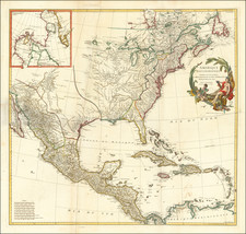
Herman Moll's celebrated "Codfish map" of North America, one of the earliest large format maps of North America printed in England.
This highly decorative large-format map of North America and the West Indies is populary known as the "Codfish Map" due to its adornment with a large engraving of fishermen catching and drying Cod along the shores of Newfoundland. It is one of the most beloved by connoisseurs, and was first issued by Herman Moll in his atlas The World Described (London, 1715), and would later be copied by Geoerge Grierson in about 1735, in Dublin.
This highly-attractive map extends from Greenland in the north down to the Spanish Main, and along the northern shores of South America. It extends westward to include the Pacific coasts and eastward all the way to include Ireland, on the opposite side of the Atlantic. The map is an excellent overview of how the British conceived of North America and the West Indies during the first half of the 18th Century. As relatively few new surveys and voyages of exploration of note occurred between 1700 and 1750, this view remained relatively static, chronologically sandwiched between two feverish periods of mapping and discovery.
The British colonies along the Atlantic Seaboard are relatively well-mapped, based on late 17th-century cartography, although curiously, New England is shown to be exaggeratedly narrowed, especially evident in Massachusetts. The cartography becomes more rudimentarily as one moves north into the Canadian Maritimes, Quebec and Newfoundland, where Moll only had access to outdated French sources. Hudson's Bay is generally well formed, due to the charting done consistently since the 1660s for the benefit of the Hudson's Bay Company. Notably, the map labels the tracks of several sea voyages into the Bay and the adjacent Canadian Arctic Archipelago, to the north.
Further inland, things become quite interesting with the appearance of the mythical 'Long River' connecting the Mississippi River with points in the far West. As stated on the map, these details are derived from Louis Armand, Baron de Lahontan, a notorious French adventurer and fraudster who claimed to have discovered this waterway in the 1690s. He included the detail on a map within his bestseller Nouveaux Voyages dans l'Amerique Septentrionale (1703). The 'Long River' was accepted and incorporated into the populart cartographic conception of the region by most of the leading mapmakers of the time, including Guillaume de L'Isle, the mapmaker to Louis XIV, and Moll.
Generally, the Great Lakes and the Mississippi are relatively well formed, based on French and Jesuit sources. In the Southwest, New Mexico and the Rio Grande are shown in a roughly accurate fashion. California is prominently depicted to be an island, including the note that "New Albion" was discovered by Sir Francis Drake in 1578, a detail included by Moll, who was an ardent partisan of the British cause. The Pacific Northwest is labeled as "Parts Unknown", although it shows the mouth of the apocryphal 'Straits of Anian', a hoax concocted in 1706, which proposes a version of the fabled Northwest Passage.
The depiction of the West Indies and the Spanish Main is conventional for the period, and features the tracks of the Spanish 'Flota', or fleets of treasure galleons, from Veracruz, Panama and Cartagena, to Havana and then onwards across the Atlantic to Seville. Moll was personal friends with many of the leading British privateers of the era, and maintained a particular interest in potential targets for state-sanctioned piracy.
A very curious and notable aspect of the map is the depiction of the prevailing trade winds, in the manner pioneered by the brilliant English scientist and thematic cartographer, Sir Edmund Halley (1656-1742). Moll, a friend of Halley, was well aware that an understanding of these phenomena was crucial to Trans-Atlantic navigation.
The left side of the composition features a veritable pageant of artistic embellishments. In the center is the famous aforementioned 'Codfish View'. Far beyond being a mere artistic conceit, it is symbolic of the Codfish industry of Newfoundland, which since 1713 was dominated by the British, and was the second largest source of wealth from North America, rivaled only by Virginia's tobacco crop.
At the bottom left are a series of 10 vignettes of plans of key New World ports, including: St. John's, Newfoundland; Boston; New York; Charleston, South Carolina; Port Royal & Kingston, Jamaica; Havana; Portobello, Panama; Veracruz, Mexico; Cartagena, Colombia and Acapulco, Mexico (importantly the western terminus of the Spanish 'Manila Galleons', which travelled across the Pacific between Mexico and the Philippines).
The magnificent late English Baroque cartouche in the upper-left corner of the map is framed by figures of Native Americans and Inuit, while the treasures of the continent lie below. Within the cartouche itself, replacing Moll's original dedication, Grierson dedicates the map to Hugh Boulter (1672-1742), who served as Lord Archbishop of Armagh, the Anglican Primate of All Ireland, from 1724 until his death. Boulter was also the chaplain to King George I from 1719 to 1727. As Grierson was a major printer of Bibles and other religious texts, the archbishop would have been one of his most important and longest-standing clients. Boulter's coat of arms surmounts the cartouche.
Herman Moll (1654-1732), was one of the most important cartographers working in England during the late 17th and early 18th Century. Originally from Germany, he immigrated to England in 1678, and made his name as an engraver for the likes of Christopher Browne, Robert Morden and Philip Lea. His first publication in his own name to feature maps was A System of Geography (1701).
This was followed by Fifty-six new and accurate maps of Great Britain (1708), and the Atlas Geographus (1711-17). His greatest masterpiece, The World Described (1715), contained 30 large maps, and ran into numerous editions. Highlights of the atlas included the "Codfish Map" and the "Beaver Map" (an edition of which was also made by Grierson).
Notably, Moll made close friends in the naval and maritime community, such as the pirate-intellectual William Dampier. From this Moll developed a particular fascination with British overseas trade and privateering, lending his maps a unique and fascinating flavor.
Moll's Codfish map is one of the great icons of 18th Century English cartography and highly prized among collectors.
Herman Moll (c. 1654-1732) was one of the most important London mapmakers in the first half of the eighteenth century. Moll was probably born in Bremen, Germany, around 1654. He moved to London to escape the Scanian Wars. His earliest work was as an engraver for Moses Pitt on the production of the English Atlas, a failed work which landed Pitt in debtor's prison. Moll also engraved for Sir Jonas Moore, Grenville Collins, John Adair, and the Seller & Price firm. He published his first original maps in the early 1680s and had set up his own shop by the 1690s.
Moll's work quickly helped him become a member of a group which congregated at Jonathan's Coffee House at Number 20 Exchange Alley, Cornhill, where speculators met to trade stock. Moll's circle included the scientist Robert Hooke, the archaeologist William Stuckley, the authors Jonathan Swift and Daniel Defoe, and the intellectually-gifted pirates William Dampier, Woodes Rogers and William Hacke. From these contacts, Moll gained a great deal of privileged information that was included in his maps.
Over the course of his career, he published dozens of geographies, atlases, and histories, not to mention numerous sheet maps. His most famous works are Atlas Geographus, a monthly magazine that ran from 1708 to 1717, and The World Described (1715-54). He also frequently made maps for books, including those of Dampier’s publications and Swift’s Gulliver’s Travels. Moll died in 1732. It is likely that his plates passed to another contemporary, Thomas Bowles, after this death.
![[ First State of the First Map of America ] Novae Insulae XVII Nova Tabula](https://storage.googleapis.com/raremaps/img/small/94609.jpg)
![[Signed Political Satire Artwork] Vietnam ... Vietnam ... Vietnam ...](https://storage.googleapis.com/raremaps/img/small/68726.jpg)
![[Hand Drawn Map] Le Golfe de Mexique avec les Pays Circonvoisins](https://storage.googleapis.com/raremaps/img/small/91580.jpg)
![Oceani Occidentalis Seu Terrae Novae Tabula [The Admiral's Map]](https://storage.googleapis.com/raremaps/img/small/102935.jpg)