
Search
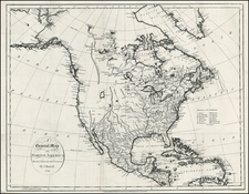
Place/Date:
London / 1795
Size:
21 x 16 inches
Condition:
VG
Stock#:
100759
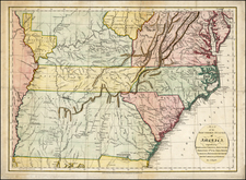
Place/Date:
London / 1799
Size:
19.5 x 13.5 inches
Condition:
VG
Stock#:
102911
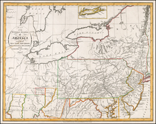
Place/Date:
London / 1802
Size:
9 x 7.5 inches
Condition:
VG
Stock#:
70335
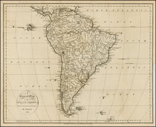
Place/Date:
London / 1811
Size:
17.5 x 15.5 inches
Condition:
VG
Stock#:
99800
Archived

Place/Date:
London / 1769
Size:
15.5 x 12 inches
Condition:
VG+
Stock#:
6831
Place/Date:
London / 1770 circa
Size:
11 x 8 inches
Condition:
VG+
Stock#:
18958

Place/Date:
/ 1780 circa
Size:
19.5 x 9 inches
Condition:
VG
Stock#:
85439
Place/Date:
London / 1792
Size:
9 x 7.5 inches
Condition:
VG
Stock#:
5800
Place/Date:
London / 1794
Size:
18.5 x 14.5 inches
Condition:
VG
Stock#:
0227
Place/Date:
London / 1794
Size:
18.5 x 14.5 inches
Condition:
VG
Stock#:
0542

Place/Date:
London / 1794
Size:
18 x 15 inches
Condition:
VG
Stock#:
12747

Place/Date:
London / 1794
Size:
18 x 14 inches
Condition:
VG
Stock#:
8704
Place/Date:
London / 1794
Size:
18 x 14 inches
Condition:
VG
Stock#:
16112

Place/Date:
London / 1794
Size:
18.25 x 11.25 inches
Condition:
Stock#:
17295
Place/Date:
London / 1794
Size:
18.5 x 14.5 inches
Condition:
VG
Stock#:
22229
Place/Date:
London / 1794
Size:
18.5 x 14.5 inches
Condition:
VG
Stock#:
22741
Place/Date:
London / 1794
Size:
18 x 14 inches
Condition:
VG
Stock#:
31812

Place/Date:
London / 1794
Size:
20 x 14 inches
Condition:
VG
Stock#:
31840
Place/Date:
London / 1794
Size:
18 x 15 inches
Condition:
VG
Stock#:
31878

Place/Date:
London / 1794
Size:
18.5 x 14.5 inches
Condition:
VG
Stock#:
34335

Place/Date:
London / 1794
Size:
18 x 14.5 inches
Condition:
VG
Stock#:
33874

Place/Date:
London / 1794
Size:
18.5 x 14.5 inches
Condition:
VG
Stock#:
34393
Place/Date:
London / 1794
Size:
18 x 14.5 inches
Condition:
VG
Stock#:
40023

Place/Date:
London / 1794
Size:
18.5 x 14.5 inches
Condition:
VG
Stock#:
38562
Place/Date:
London / 1794
Size:
18 x 14.5 inches
Condition:
VG
Stock#:
40076

Place/Date:
London / 1794
Size:
18 x 14 inches
Condition:
VG
Stock#:
41873
Place/Date:
London / 1794
Size:
20 x 14 inches
Condition:
VG
Stock#:
40152
Place/Date:
London / 1794
Size:
20 x 14 inches
Condition:
VG
Stock#:
40234

Place/Date:
London / 1794
Size:
18 x 15 inches
Condition:
VG+
Stock#:
55466
Place/Date:
London / 1794
Size:
18.5 x 14.5 inches
Condition:
VG
Stock#:
40057
Place/Date:
London / 1794
Size:
18.5 x 14.5 inches
Condition:
VG
Stock#:
54373
Place/Date:
London / 1794
Size:
18.5 x 14.5 inches
Condition:
VG
Stock#:
40367
Place/Date:
London / 1794
Size:
18 x 15 inches
Condition:
VG
Stock#:
40328

Place/Date:
London / 1794
Size:
18 x 14 inches
Condition:
VG
Stock#:
40218
Place/Date:
London / 1794
Size:
18 x 14 inches
Condition:
VG
Stock#:
46210
Place/Date:
London / 1794
Size:
18 x 15 inches
Condition:
VG
Stock#:
44403
Place/Date:
London / 1794
Size:
18.5 x 14.5 inches
Condition:
VG
Stock#:
53871

Place/Date:
London / 1794
Size:
18.5 x 14.5 inches
Condition:
VG
Stock#:
57349
Place/Date:
London / 1794
Size:
18.5 x 14.5 inches
Condition:
VG
Stock#:
56596

Place/Date:
London / 1794
Size:
17.5 x 15 inches
Condition:
VG
Stock#:
70269mp2
Place/Date:
London / 1794
Size:
18.5 x 14.5 inches
Condition:
VG+
Stock#:
71531

Place/Date:
London / 1794
Size:
17.75 x 15 inches
Condition:
VG
Stock#:
71559
Place/Date:
London / 1794
Size:
18.5 x 14.5 inches
Condition:
VG+
Stock#:
83361
Place/Date:
London / 1794
Size:
17.75 x 15 inches
Condition:
VG
Stock#:
83651

Place/Date:
London / 1794
Size:
17.75 x 15 inches
Condition:
VG+
Stock#:
92498
Place/Date:
London / 1794
Size:
18.5 x 14.5 inches
Condition:
VG
Stock#:
100407

Place/Date:
London / 1795
Size:
18 x 14.5 inches
Condition:
VG+
Stock#:
m0417

Place/Date:
London / 1795
Size:
20.5 x 16 inches
Condition:
VG
Stock#:
24853
Place/Date:
London / 1795
Size:
20.5 x 16 inches
Condition:
VG
Stock#:
40523
Place/Date:
London / 1795
Size:
20.5 x 16 inches
Condition:
VG
Stock#:
55168

Place/Date:
London / 1795
Size:
20.5 x 16 inches
Condition:
VG
Stock#:
57332

Place/Date:
New York / 1795
Size:
8.5 x 7.3 inches
Condition:
VG
Stock#:
70649
Place/Date:
London / 1795
Size:
20.75 x 16 inches
Condition:
VG+
Stock#:
81236
Place/Date:
London / 1795 circa
Size:
8 x 7 inches
Condition:
VG
Stock#:
95458