This item has been sold, but you can enter your email address to be notified if another example becomes available.


|
||

|

|
|

|
Stock# 99717
Description
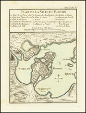
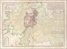
One of the earliest obtainable maps of Boston
Interesting and detailed map of the Port of Boston and Vicinity, published at the conclusion of the French & Indian War.
Includes towns, Islands, soundings, etc.
From the Gazzettiere Americano published in Livorno in 1763, based upon an earlier work by Thomas Jefferys, which did not include any maps.
![Carte Reduite Des Costes Orientales De L'Amerique Septentrionale . . . contenant L'Isle Royale . . . La Nouvelle Angleterre et la Nouvelle Yorc . . . MDCCLVII [with Plan of Boston Harbor] Plan du Havre de Baston](https://storage.googleapis.com/raremaps/img/small/80006.jpg)