The item illustrated and described below is sold, but we
have another example in stock. To view the example which
is currently being offered for sale, click the
"View Details" button below.
![[ Brazil ] Carte Du Bresil . . . 1829 By Alexandre Emile Lapie](https://storage.googleapis.com/raremaps/img/small/99602.jpg)


|
||

|

|
|

|
Stock# 99382
Description
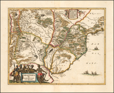
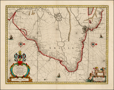
Striking map of Brazil, Bolivia, Upper Peru, Paraguay and Uruguay, at the close of the colonial period.
Shows towns, roads, rivers, lakes, mountains, islands, bays, points, etc. Fascinating hachuring style to represent the various mountains and river valleys. Terrific detail in the interior.