|
||

|

|
|

|
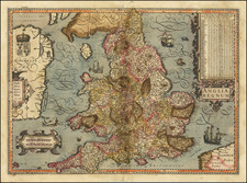
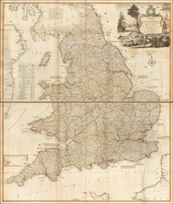
This circa 1645 map by Jan Jansson presents a decorative depiction of England, Scotland, and Wales, highlighting the Saxon Kingdoms of Britain from the 5th to 6th centuries.
Known as the Saxon Heptarchy map, it is very similar to Joan Blaeu's map of the same title, both of which are based upon John Speed's 1611 map. Jansson's version, however, distinguishes itself with the addition of three compass roses, rhumb lines, and sailing ships, enriching the maritime context of the map.
The map features two sets of vignettes flanking the main cartographic depiction, showcasing significant historical scenes from Saxon history between 456 and 662 A.D. These vignettes, redesigned by a Dutch engraver, are rendered in the grand style of contemporary Dutch paintings, providing a visually engaging historical narrative alongside the geographical representation.
As one of the most decorative and sought-after atlas maps of Great Britain published in the 17th century, Jansson's map is notable for its artistic merit and historical significance. The intricate detailing and the integration of historical vignettes make it a valuable artifact for both collectors and scholars of early modern cartography.
Jan Janssonius (also known as Johann or Jan Jansson or Janszoon) (1588-1664) was a renowned geographer and publisher of the seventeenth century, when the Dutch dominated map publishing in Europe. Born in Arnhem, Jan was first exposed to the trade via his father, who was also a bookseller and publisher. In 1612, Jan married the daughter of Jodocus Hondius, who was also a prominent mapmaker and seller. Jonssonius’ first maps date from 1616.
In the 1630s, Janssonius worked with his brother-in-law, Henricus Hondius. Their most successful venture was to reissue the Mercator-Hondius atlas. Jodocus Hondius had acquired the plates to the Mercator atlas, first published in 1595, and added 36 additional maps. After Hondius died in 1612, Henricus took over publication; Janssonius joined the venture in 1633. Eventually, the atlas was renamed the Atlas Novus and then the Atlas Major, by which time it had expanded to eleven volumes. Janssonius is also well known for his volume of English county maps, published in 1646.
Janssonius died in Amsterdam in 1664. His son-in-law, Johannes van Waesbergen, took over his business. Eventually, many of Janssonius’ plates were sold to Gerard Valck and Pieter Schenk, who added their names and continued to reissue the maps.