|
||

|

|
|

|
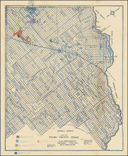
Plan For the Worst
Strategic map of Dallas, Texas created by the United States Air Force to plan for possible operations or attacks in the area. This chart is one in a series that illustrates the United States, including key population data such as the density of an area (in yellow) or the location of major hubs of activities like stadiums, rail lines, and airports.
The map primarily focuses on illustrating infrastructure, like powerlines, pipelines, mines, and canals. This focus was to determine what could be strategic places for enemies to conduct an airstrike. Considering this was produced at the beginning of the Cold War, the prospect of an enemy air raid was not unheard of, especially for a major metropolitan area like Dallas. Overall an interesting historical chart that subtly illustrates the domestic tensions of the Cold War.
This map was classified as restricted material, intended only for internal governmental use, and an obsolete classification as of November 5, 1953. The title states this is the 1st edition, published in July 1951.

![[ European Cooperation ] Organisation Europeenne de Cooperation Economique](https://storage.googleapis.com/raremaps/img/small/78837.jpg)
![(Texas) Denkschrift über eine Reise nach Nord-Mexiko, verbunden mit der Expedition des Obersten Donniphan, in den Jahren 1846 und 1847. Von Dr. A. Wislizenus. Aus dem Englischen übertragen von George M. von Ross. Mit einem wiffenschaftlichen Anhange und drei Karten. [Description of a voyage to northern Mexico connected with Colonel Doniphan's expedition in 1846 and 1847 By Dr. A. Wislizenus. Translated from the English by George M. von Ross. With a scholarly appendix and three maps.]](https://storage.googleapis.com/raremaps/img/small/88574.jpg)