The item illustrated and described below is sold, but we
have another example in stock. To view the example which
is currently being offered for sale, click the
"View Details" button below.
![[ Republic of Texas ] Texas By Carl Flemming](https://storage.googleapis.com/raremaps/img/small/104906.jpg)


|
||

|

|
|

|
Stock# 14457
Description
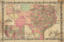
A highly detailed map of the Republic of Texas, often called the German Arrowsmith, from which it derives its cartography.
Texas is shown in its maximum Republic configuration, with 30 counties identified in outline color. This map is certainly one of, if not the most detailed maps dedicated to the Republic of Texas to have appeared in an American atlas. It is especially strong in identifying early roads, rivers, towns and forts often not shown on other contemporary maps of Texas. Inset of Galveston Bay. The panhandle is divided into 12 sections. A scarce and desireable map.
Condition Description
Minor foxing and toning, else a nice example.
Reference
Day p. 37; Texas State Archives 1457. Not in Streeter.
![Carta geografica della Florida nell'America settentrionale [Geographical map of Florida in North America]](https://storage.googleapis.com/raremaps/img/small/84142.jpg)
![[ Southern California Water Explorations ] Topographical Sketch showing the Outward and Inward Route of A Party, while examining the practicability of a Diversion of the Colorado River for Purposes of Irrigation under the Command of 1st Lieut. Eric Bergland Corps of Engineers, U.S. Army 1875](https://storage.googleapis.com/raremaps/img/small/98208.jpg)
![Karte von Tejas und den angrenzenden Theilen Mejicos . . . [with California Gold Regions Inset]](https://storage.googleapis.com/raremaps/img/small/61669.jpg)