|
||

|

|
|

|
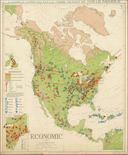
This 1952 map, titled "Climate Winter Conditions" from the Philips Commercial Wall Atlas of North America wall map series, provides a detailed depiction of the winter climate across North America.
The map delineates temperature ranges, precipitation levels, and prevailing wind patterns, using distinct colors and labels for each climatic zone. Intended for commercial use, it would have aided businesses in sectors such as agriculture and transportation by offering crucial climate data for planning and decision-making.
The map showcases the cartographic techniques of its era, with a focus on clarity and legibility. It features shading and symbols to represent different climatic features, all explained in an accompanying legend. Published during a period of economic growth in the post-World War II era, it reflects the contemporary interest in resource management and logistics optimization.
![[ First Map to Name The United States ] L'Amerique septentrionale ou se remarquent les Etats Unis . . . 1779](https://storage.googleapis.com/raremaps/img/small/94192.jpg)
![[First State of the Popple Key Sheet] A Map of the British Empire in America with the French and Spanish Settlements adjacent thereto by Hen. Popple.](https://storage.googleapis.com/raremaps/img/small/92714.jpg)