|
||

|

|
|

|
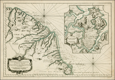
Nice example of the Buchon's map of Guyana, published in Paris in 1825.
The map provides a comprehensive geographical, statistical, and historical overview of the region known as Guyana, encompassing present-day Guyana, Suriname, and French Guyana. Created during a period of significant colonial interest and activity in South America, this map is a valuable artifact of the era's cartographic and geopolitical landscape. The map is exceptionally detailed, with forts, towns, villages, mountains, rivers, etc. Includes river portages, the "supposed course of the Maroni River" and a host of other topographical and geographical details.
In the early 19th century, Guyana was a region of considerable colonial rivalry among European powers, specifically the British, Dutch, and French. The map was produced following the Congress of Vienna (1814-1815), which redefined colonial boundaries and influenced subsequent territorial claims. This period saw increased European interest in the economic potential of Guyana's resources, including sugar, coffee, and other plantation crops, as well as its strategic importance along the Atlantic coast.
The map is distinguished by its detailed representation of the region's topography, hydrography, and settlement patterns. It prominently features major rivers such as the Essequibo, Demerara, and Courantyne, essential for transportation and trade. The map also delineates colonial boundaries with precision, highlighting the distinct territories of British Guyana, Dutch Guyana (Suriname), and French Guyana. The use of color to differentiate these territories is both visually striking and informative.
Accompanying the map are extensive textual descriptions on either side, providing statistical and historical information about the different regions of Guyana. These texts offer insights into the economic activities, natural resources, and colonial administration of the time. The inclusion of such data underscores the map's dual purpose as both a navigational tool and a comprehensive reference for scholars and administrators.
Jean Alexandre Buchon (1791-1849) was a French scholar and historian. Born as the French Revolution raged, Buchon was dedicated to recovering France’s history in order to help the country heal and grow. He gathered French stories and published them as part of Collection des chroniques nationales franciases ecrites en langue vulgaire, du XIe au XVIe siècle (4 vols, 1824-1829). He also compiled and published an exploration collection and several histories, particularly about medieval France.
For geography, his most important contribution was publication of the French edition of Carey & Lea’s American Atlas in 1825. Each page of the atlas includes highly detailed text about the state or territory depicted, as well as a map of the area. The French edition is generally considered in high regard as compared to other editions, as it has quality paper and superior engraving.
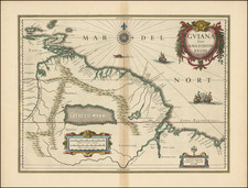
![[El Dorado] Guaiana](https://storage.googleapis.com/raremaps/img/small/97225.jpg)
![[Cayenne, French Guiana] Land-Kaart van het Eiland en de Volkplanting van Cayenne aan de Kust van Zuid-Amerika](https://storage.googleapis.com/raremaps/img/small/62052.jpg)