|
||

|

|
|

|
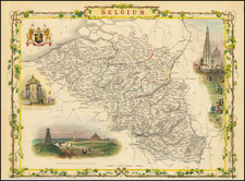
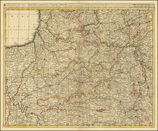
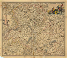
This map depicts the Southern Netherlands, known today as Belgium, along with parts of modern-day France, Germany, and the Netherlands. This detailed map is both a geographical representation and an artistic masterpiece, offering a glimpse into the political and cultural landscape of early 18th-century Europe.
In the early 18th century, the region depicted on this map was a mosaic of territories controlled by various European powers. The Southern Netherlands were part of the Spanish Netherlands until the Treaty of Utrecht in 1713, which transferred control to the Austrian Habsburgs, marking the beginning of the Austrian Netherlands era. This period was characterized by a relative stability and economic growth, with significant development in commerce, industry, and urbanization.
Prominent cities such as Brussels, Antwerp, Ghent, and Bruges are clearly marked, reflecting their importance as commercial and political hubs. The map also shows major rivers, including the Scheldt (Schelde), Meuse (Maas), and Rhine (Rijn), which were vital for trade and transport.
The map features an elaborate allegorical cartouche in the upper left corner, which is typical of Seutter's work. This cartouche is richly decorated with figures representing various aspects of the region's identity and importance. A cherub holding a banner inscribed with the map's title is flanked by personifications of Strength and Wisdom, symbolizing the region's resilience and intellectual heritage. The presence of a Roman soldier and other mythological figures further emphasizes the historical depth and cultural significance of the area.
Beneath the main map, there is an inset map of Ostende, a strategic port city on the North Sea. This inset provides a detailed view of the city's fortifications, reflecting its military importance.
Matthäus Seutter (1678-1757) was a prominent German mapmaker in the mid-eighteenth century. Initially apprenticed to a brewer, he trained as an engraver under Johann Baptist Homann in Nuremburg before setting up shop in his native Augsburg. In 1727 he was granted the title Imperial Geographer. His most famous work is Atlas Novus Sive Tabulae Geographicae, published in two volumes ca. 1730, although the majority of his maps are based on earlier work by other cartographers like the Homanns, Delisles, and de Fer.
Alternative spellings: Matthias Seutter, Mathaus Seutter, Matthaeus Seutter, Mattheus Seutter