|
||

|

|
|

|
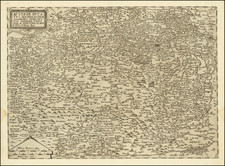
This late 18th-century map provides a detailed representation of the area surrounding Vienna, the capital of the Habsburg Monarchy. The map is characterized by its precise delineation of topographical features, urban settlements, and transportation routes, reflecting the cartographic standards of the Enlightenment era.
The central focus of the map is Vienna, prominently encircled in red, emphasizing its significance as a major political, cultural, and economic hub. Surrounding the city, the map details the intricate network of roads and pathways connecting Vienna to its neighboring towns and villages, showcasing the region's connectivity and infrastructure.
Notable geographical features such as the Danube River, which flows prominently through the map, are meticulously rendered. The river's course, along with its branches and adjacent wetlands, is depicted with remarkable accuracy, highlighting its importance for trade and transportation. The surrounding landscape, including hills, forests, and agricultural areas, is carefully illustrated, providing insights into the region's natural resources and land use.
The map also includes numerous towns and villages, each marked with their respective names, offering a comprehensive view of the settlements that comprised the greater Vienna area during this period. The inclusion of smaller hamlets and estates further underscores the map's attention to detail and its value as a historical document.
From Von Reilly's exceedingly scarce Schauplatz der funf Theile der Welt. Von Reilly and Schraembl led a revival of map making in Vienna in the late 18th century which included this and several other sought after works.
![(Italy and Austria) Carta geografica statistica postale dell’I.R. Monarchia Austriaca e dell’Italia [Statistical postal geographic map of the Imperial Royal Austrian Monarchy and of Italy]](https://storage.googleapis.com/raremaps/img/small/94038.jpg)
![Vienna [Wien]](https://storage.googleapis.com/raremaps/img/small/93386.jpg)