|
||

|

|
|

|
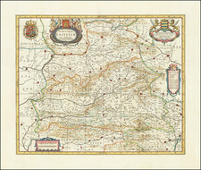
The Kingdom of Navarra By Spain's Most Important 18th Century Mapmaker
This detailed map, crafted by the esteemed Spanish cartographer Tomás López de Vargas Machuca in 1772, meticulously depicts the Kingdom of Navarre, encompassing the Merindades of Pamplona, Estella, Tudela, Sangüesa, and Olite. López's work is renowned for its precision and elegance, reflecting the cartographic advancements and geographic knowledge of the enlightenment period of late 18th-century Spain.
The map is segmented into multiple panels, each delineating the intricate topography, settlements, and administrative divisions of Navarre. The boundaries of the Merindades are outlined in different colors, facilitating easy differentiation between these historical territorial units. Key cities, towns, valleys, and local jurisdictions (cendeas) are prominently marked, showcasing the region's rich urban and rural landscape.
Navarre's strategic location, bordered by France to the north and other significant Spanish territories such as Alava and Aragon, is highlighted, emphasizing its historical importance as a crossroads of cultures and political entities. The detailed depiction of rivers, mountains, and roads further underscores López's commitment to geographic accuracy and his contribution to the cartographic tradition of the Enlightenment period.
Tomás López, appointed as the Royal Geographer to the King of Spain, was instrumental in the creation of numerous maps that significantly improved the contemporary understanding of Spain's geography. His meticulous work, often based on extensive surveys and consultations with local experts, was part of a broader effort to enhance navigation, administration, and economic planning during a period of significant territorial consolidation and exploration.
The Mapa Del Reyno De Navarra serves as a valuable historical document, providing insights into the territorial organization and geographic knowledge of 18th-century Spain. Collectors and historians alike prize López's maps for their aesthetic quality, historical significance, and the light they shed on the geographic and political landscapes of their time. This map, in particular, stands as a testament to the rich history and intricate administrative structure of the Kingdom of Navarre.
Tomás López de Vargas Machuca (1730-1802) was one of Spain’s most prominent cartographers in the eighteenth century. He was born in Toledo but studied at the Colegio Imperial in Madrid, where he focused on mathematics, grammar, and rhetoric. Along with a small group of colleagues, in 1752 the Spanish government sent López for training in Paris with the renowned geographer Jean Baptiste Bourguignon d’Anville. When he returned to Spain he was named Geógrafo de los dominios de Su Magestad and put in charge of the geographic collections of Charles III. He published many maps, including his fascinating maps of the Americas, and a variety of geography manuals. Some of his most famous maps are of the Iberian Peninsula, part of his large project to create a majestic atlas of Spain. Unfinished in his lifetime, López's children published the Atlas Geográfico de España (Geographical Atlas of Spain) in 1804. It was republished in 1810 and 1830.
![[Alhambra / Granada ] Alhama](https://storage.googleapis.com/raremaps/img/small/77312.jpg)