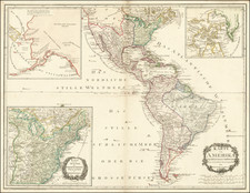
|
||

|

|
|

|
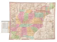
Celebrating The Statue of Liberty's Unveiling in New York City
Rare separately published map of the United States, published by Rand McNally & Company.
The map provides a remarkably detailed look at the railroads of the United States, as well as topographical and other details.
The image of the Statue of Liberty coincides with the unveiling in New York on October 28, 1886. Following the construction of a pedestal on Bedloe Island to accommodate France's gif
-
Construction and Assembly (1881-1886):
- The pedestal was designed by American architect Richard Morris Hunt and constructed on Bedloe’s Island (now Liberty Island) in New York Harbor.
- The statue was completed in France in 1884 and then disassembled and shipped to the United States in early 1885. It arrived in June of that year and was reassembled on its pedestal over the next several months.
-
Unveiling (October 28, 1886):
- The Statue of Liberty was dedicated on October 28, 1886, in a ceremony presided over by President Grover Cleveland. The event was marked by much fanfare and was attended by thousands of people.
Rarity
This is the only example of the map we have seen on the market.
Rand McNally & Co. is a large American map and navigation company best known for its annual atlases. The company got its start in 1856, when William Rand opened a print shop in Chicago. He was joined in 1858 by a new employee, Andrew McNally. Together, the men established their namesake company in 1868. Originally, the company was intended to print the tickets and timetables for the trains running to and through Chicago; their first railway guide was published in 1869.
By 1870, they had shifted from just printing to publishing directories, travel guides, and newspapers. Their first map appeared in 1872 in a railway guide. The map was produced using a new wax engraving method, a cheaper process that gave the company an edge.
By 1880 Rand McNally had entered the education market with globes, wall maps, and geography texts for students. In 1923, Rand McNally published the first Goode’s World Atlas, named after its editor, Dr. J. Paul Goode. For generations afterward, this would be the standard classroom atlas.
In 1899, William Rand left the company, but McNally and his family remained, controlling the company for over a century. In 1904, they published their first road map intended for automobiles and by 1907 were publishing Photo-Auto Guides, which combined photography and mapping to help drivers. In 1924, they produced the Auto Chum, a precursor to their famous road atlases. Rand McNally would remain the leader in road maps and atlases throughout the twentieth century.
In 1937, Rand McNally opened its first store in New York City. Ever on the frontier of technology, Rand McNally pioneered the scribing process for printing tickets in 1958 and printed their first full-color road atlas in 1960. Arthur Robinson developed his now-famous projection of Rand McNally in 1969. By the 1980s, the company was exploring digital reproduction and digital databases of maps for truckers. In the 1990s, they lead the charge to develop trip-planning software and websites. Today, most of its products are available online or in a digital format, including maps for tablets and phones.
![[ Shows Colona ] Map of the United States and Mexico. Published . . . Under the Direction of Col. Carlos Butterfield. December 1859](https://storage.googleapis.com/raremaps/img/small/103272.jpg)


![[ Missouri named State of Jefferson ] Etats-Unis par A.M. Perrot](https://storage.googleapis.com/raremaps/img/small/99019.jpg)