The item illustrated and described below is sold, but we
have another example in stock. To view the example which
is currently being offered for sale, click the
"View Details" button below.


|
||

|

|
|

|
Stock# 100501
Description
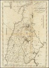
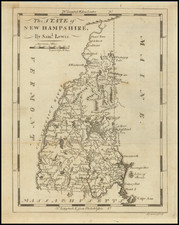
1805 edition of this early map of New Hampshire, from Mathew Carey's Pocket Atlas.
The map shows travel routes, towns, topography, rivers, and harbors. This map was based on surveys conducted by Samuel Lewis.
The engraving of the map was done by Seymour.
Condition Description
Engraving on early-19th-century wove paper.